Cool start kicks off Summer-like temps for the weekend
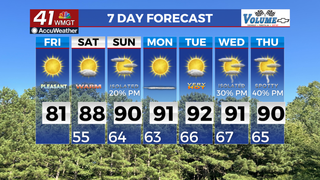
MACON, Georgia (41NBC/WMGT) – Friday morning starts off crisp, more Fall-like than Spring-like, with lows in the mid 40s to lower 50s. Winds will relax a bit and swing to the east, keeping 


fire weather conditions more marginal. We will monitor dewpoints for any dips below 25 percent. We can expect a near carbon-copy of yesterday, with highs just a few degrees warmer, in the mid 70s to lower 80s. The extended forecast will mostly focus on the dry conditions with warming temperatures into the weekend and next week. The Bermuda high settles back into the area into the weekend which will limit any approaching fronts well towards the north of our area. A shortwave pushes into far north Georgia on Sunday but with a deep layer of dry air, rainfall is not expected 


to occur. As the ridging settles in temperatures will begin their warming trend with highs in the mid to upper 80s across the area each day next week with portions of far southeastern Middle Georgia potentially reaching 90 degrees. Lows are only expected to dip down into the mid to upper 60s most nights as well with temperatures as a whole 7 to 12 degrees above normal. Towards the end of the long term forecast, there is an indication that a front will push into the area bringing in rainfall Wednesday into Thursday only if the front holds together. Overall the outlooks are indicating a return to above normal rainfall and above normal temperatures.