A brief cooldown then plenty of heat
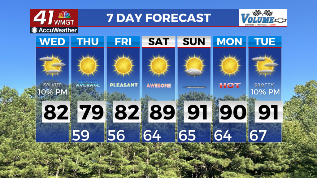
MACON, Georgia (41NBC/WMGT) – Mostly dry conditions through Friday as northwest flow reigns supreme. There is a potential for a few small showers, (maybe a rumble of thunder) as a dry 


front moves into the area from the northwest today. The greatest chance for this will be in the Northeast Georgia mountains. Timing wise, the greatest chances will be later in the afternoon to evening. Conditions clear out with temperatures briefly dipping on Thursday, before an upswing into the weekend. High pressure over the area continues into the extended period keeping things dry through early next week. C0oler temps begin the extended period however that will be short-lived. Friday morning lows will be in the 40s to lower 50s with temps beginning to rebound as 


high temperatures get into the lower to middle 80s. By Saturday morning a weak wave moves Southeast out of the Central Plains and into Kentucky/Tennessee. We will see some increase moisture across the state but still not expecting any rain. Mainly increased cloud cover but temps will get up into the 80s to near 90. These elevated temperature continue Sunday into Monday with no precipitation in site. These warm and dry conditions going into the weekend, may bring back some fire weather concerns. Most of the state has received enough rain to reduce some of the risk that we are still facing.