Stingy showers for Middle Georgia; increased chances further south
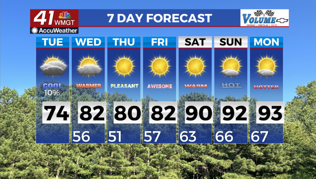
MACON, Georgia (41NBC/WMGT) – The damp period has come to an end, for most in our viewing area, with post frontal dry air settling across the area and a surface high to the northeast that’s 


driving northeast flow into the area. This will further dry conditions through the short term period. A few spotty showers may be possible through Wednesday as a stalled front settles across the Gulf Coast. Any precipitation from this feature will be trace at best and likely won’t reach further than a couple of counties into our coverage area. Temperatures will be comfortable through Thursday, with highs in the mid to upper 70s and maybe even low 80s. Skies over Georgia generally clearing over the next three days. A dry front on Thursday, while not bringing any rainfall, will bring even further dry conditions. Dewpoints may fall into the low 40s, resulting in Relative Humidity Values in the 30 percent or below. A fairly dry cold front sweeps through the area 


Wednesday into Wednesday night finally pushing off the Georgia coast Thursday morning. High pressure builds in behind this front and keeps things mostly dry through the weekend. Cooler temps move in behind this cold front with low Thursday morning dipping into the 50s to lower 60s with highs Thursday in the 70s to lower 80s. These cooler temps continue Friday morning with 

lows in the 40s to lower 50s. These temps do start to rebound Friday as highs get up into the lower to middle 80s. By Saturday morning, a weak wave moves southeast out of the Central Plains and into Kentucky/Tennessee. We will see some increase moisture across the state but still not expecting much precipitation. With these dry conditions going into the weekend, this may bring back some fire weather concerns. Most of the state has received enough rain to reduce some of the risk that we were facing.