Heavy rain and storms continue through the day
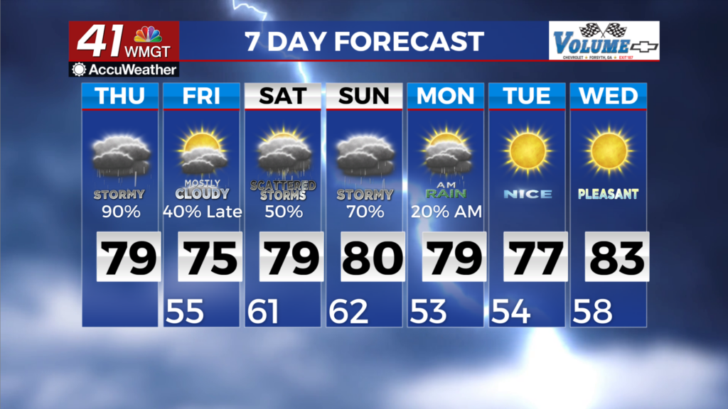
MACON, Georgia (41NBC/WMGT) – The radar remains active for much of Northern and portions of Western Georgia this morning, as scattered showers and thunderstorms overspread the 


area. We’ve had a few thunderstorms take advantage of the favorable environment to produce pea to quarter-sized hail. While instability has waned, it is anticipated that a resurgence of instability, enhanced shear and spin within the vicinity of the front will occur. Therefore, the severe threat continues through the early morning. Although the Tornado Watch has been cancelled 


for our area, all hazards damaging winds, and a few tornadoes are all on the table. Additionally, we are concerned about flooding due to “training” thunderstorms. In other words, storms with very heavy rainfall rates moving over the same locations. Despite ongoing drought conditions, heavy rainfall over a short period of time will still contribute to the flash flooding threat for these areas that see training storms, any low lying or poor drainage areas and urban areas, especially over portions of Middle Georgia in an area from Carrollton to Columbus eastward towards Atlanta and Macon. A Flood Watch remains in effect for most of the area where largely 1.5 to 2.5 inches of rain can be expected through Thursday morning. Locally higher amounts, 3 to 5+ inches, especially with any strong thunderstorms, are also possible. With the threat for severe and flooding persisting, it’s very important to ensure that you have a plan of action ready in the event a warning is issued and you need to shelter quickly.