Possible strong storms on the way for Middle Georgia tonight
MACON, Georgia (41NBC/WMGT) – Low to mid-level flow has turned to the south to southwest and is drawing in warm moist air. Dewpoints are slowly rising and should be mainly in the lower 


60s. Currently there are no showers in Middle Georgia however in northwest Georgia showers have begun to move in. These showers are associated with the approaching frontal system oriented northeast to southwest across Tennessee/Kentucky. As the frontal boundary pushes southeast into the warm and humid airmass, it’s likely to create multiple rounds of widespread showers and storms across North and Middle Georgia through tonight, bringing threats for severe weather and flooding. The Storm Prediction Center has most of North and portions of Middle Georgia, 


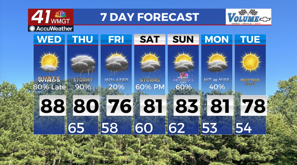
under a slight risk (Level 2 of 5) for severe weather today and tonight. Our initial severe threat may be Wednesday afternoon as isolated storms could develop across North Georgia, although confidence in these storms developing is low as there will not be much forcing. The more likely timeframe for activity is from Wednesday evening into early Thursday morning as the frontal boundary pushes slowly south through the area. Strong storms will likely be a combination of discrete supercells and bowing segments out ahead of the front in the evening, before merging into potentially embedded supercells overnight. All severe hazards could be possible in this setup, including damaging winds, large hail, and a few tornadoes. Given the high shear (spin in the atmosphere), a strong tornado could not be ruled out across North Georgia. There are some factors that could lower the overall severe threat, such as morning convection across North Georgia — that would limit instability later in the day. We will continue to monitor the situation. Our other concern is the potential for localized flash flooding mainly across north and portions of West 


Middle Georgia. The very high moisture content will contribute to efficient rain rates, with storm motion and the potential training of showers/storms only increases flood potential. As a result, the Weather Prediction Center has most of north and portions of Central Georgia in a Level 2 or 4 risk for localized flash flooding. A Flood Watch has been issued for the areas of highest concern, where a widespread 1.5 to 2.5 inches, and localized amounts of 4 inches or more will lead to the potential for flooding of poor drainage and urban areas, as well as creeks and streams prone to flash flooding. You may be wondering how could we have flooding during a significant drought? The answer is the very dry, hard ground leads to more rapid runoff and a higher flood threat than soft, wet grounds. The one thing the drought will have an influence on, is the main stream rivers are low, and will not be at risk for flooding during this weather event.