Showers & storms increase for Middle Georgia
MACON, Georgia (41NBC/WMGT) – Showers are slowly dissipating over Middle Georgia. Expect additional shower activity to stream in from Central Alabama, with embedded isolated thunderstorms. Another round of widespread showers is expected later this morning. A Marginal Risk for severe thunderstorms remains in effect for portions of our area, along a line from 


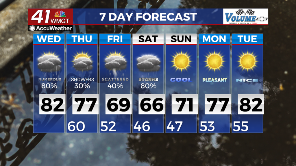
south of Columbus to the northern border of Georgia with North Carolina/South Carolina and northwest, through Wednesday morning, as well as for portions of West Middle Georgia through the day on Wednesday. Showers and thunderstorms will weaken and become more sparse in coverage through the morning. Lingering isolated showers are possible through the rest of the day. Daytime highs will likely be warmer for most of the area, in the low 70s to near 80, if showers and cloud cover lingers than anticipated, as it did yesterday, then expect high temperatures to be closer to what was seen yesterday. By Thursday morning another wave along the stalled frontal boundary will be pushing into West Georgia. Right now the models are showing the better instability chances down across the Gulf and across Florida so we should still see mainly showers with some isolated thunderstorms. Currently the Storm Prediction Center has South Georgia 

just in a general risk for Thursday. This boundary moves a bit further south Thursday afternoon then swings back northward Friday morning. This boundary will usher in a developing system across the Southern Plains that pushes into Western Georgia by daybreak Friday. The boundary then becomes stationary allowing moisture to pump into the region through the weekend with continued precipitation chances through Sunday morning. Instability is expected to stay fairly weak through this process, so mainly showers with afternoon isolated thunderstorms are expected Friday into Saturday. By Sunday, a weak high pressure ridge slides south out of the Central Plains and pushes the boundary southeast out of our coverage area. This dries things out for Sunday and Monday.