

Relief in the weather pattern is on the way
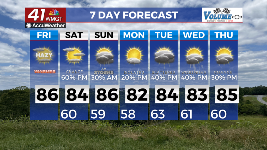
MACON, Georgia (41NBC/WMGT) – High pressure over the Southeast maintains warm, dry conditions through today. Fair-weather cumulus clouds will develop this afternoon and again for 


Saturday. A Fire Danger Statement is in effect until 8 PM this evening for Middle and Eastern Georgia due to very dry vegetation and low relative humidity. Another Fire Danger Statement will most likely be issued for Saturday across at least parts of the area. Residents are encouraged to follow instructions from their local sheriff or fire departments for information on burn restrictions or burn bans. Wildfire smoke was visible earlier on satellite imagery but has remained aloft, due to the lack of surface visibility reductions and haze reports. Weak low level to mid-level southwesterly flow will persist later today, so a hazy sky will be possible for parts of the area as wildfire smoke continues to push northward out of southern Georgia and northern Florida. 


Showers and potential storms ahead of a cold front will push into northwest Georgia Friday night into early Saturday morning, which will begin to scour out any remaining smoke over the area. A much needed change in the weather pattern is on the way. By Saturday morning a weak frontal boundary will have moved into northwest Georgia with showers and isolated thunderstorms moving southeast across the area. The low pressure system will weaken and forcing ahead of the front will diminish as it sinks into Middle Georgia, with rain becoming more scattered. High temps Saturday afternoon will get up into the mid to upper 70s along north of I-85 and into the 80s to the south. With the low level shear ahead of the front expected to be fairly weak and forcing diminishing in the afternoon, it appears that conditions will not align for a severe weather threat. We will see mainly gusty winds and frequent lightning with any thunderstorms that do 


develop. On Sunday, the front stalls across south-Middle Georgia and a weak ridge will quickly pass north of the forecast area, which will allow temps to rebound into the mid to upper 80s. The influence of this ridge will also limit precipitation chances to 20% or less across north Georgia, although the precip numbers of 30 to 40 percent will remain for areas south of Columbus and Macon. An unsettled weather pattern continues Monday as the ridge is displaced further away to the north and another disturbance overruns the stalled front. Late Monday into Tuesday, a shortwave trough and strengthening low pressure system advances from the west, with another cold front extends into the Southeast. More widespread showers and thunderstorms return late Monday night through Tuesday.