Fire weather conditions continue for North & Middle Georgia
MACON, Georgia (41NBC/WMGT) – Starting off the work week with a morning that feels chilly to some, even though temperatures will be around normal for this time of the year, sitting in 


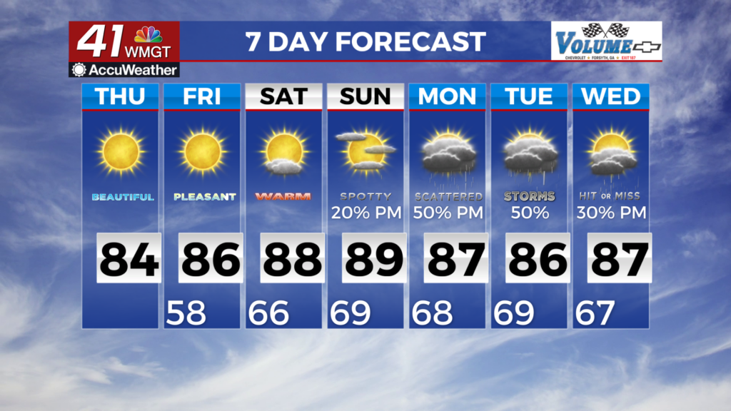
the low to mid 40s. Deep northwest flow and high pressure building over the area keeps skies mostly clear through Tuesday, and leads to a slight warming trend back to above normal temps. Highs today will range from the upper 60s in the north Georgia mountains, to the mid to upper 70s across the rest of the state. After temperatures drop into the upper 40s to low 50s tonight, they will warm into the upper 70s to low 80s on Tuesday afternoon. While these conditions sound pleasant, we will actually have fire weather concerns this week. Dry and warm weather persists Wednesday through Friday, keeping fire weather concerns on the docket each afternoon. This dry, warm weather comes courtesy of the surface high pressure continuing to extend westward from the Atlantic alongside some ridging. By late Friday, the ridge begins to flatten and moves eastward as a cold front approaches the region from the northwest. This front will lead to a welcome increase in rain chances despite the weekend timing. The initial front looks likely to become stationary in our vicinity by Saturday as midlevel flow becomes more zonal. This should allow for a more active weather pattern from the weekend and beyond as a series of disturbances brings the chance for at least scattered showers. While it remains to early to talk specifics, anything will be welcomed to hopefully take a pause on drought conditions. Additionally, more favorable severe weather initially will likely remain west of Georgia, although that could change beyond the current forecast and the long term headed into next week.