Dry conditions persist for Middle Georgia
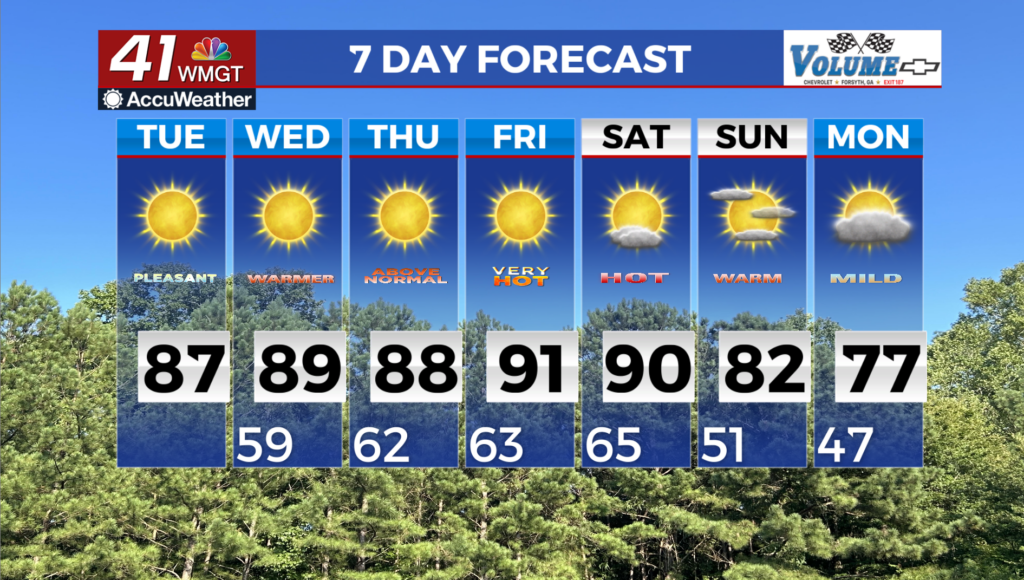
MACON, Georgia (41NBC/WMGT) – The overall pattern remains unchanged today and Wednesday, with high pressure maintaining its hold over the region. The ridge is becoming more 


centered over the Southeast keeping any frontal boundaries and precipitation displaced well to the north of Georgia. The ridge aloft and southwesterly flow from the Gulf on the back side of the high will also promote continued warming. Low temperatures this morning will be in the mid 50s to near 60s. Under mostly clear skies, high temperatures this afternoon will be 9 to 12 degrees above normal in Middle Georgia and 12 to 16 degrees above normal in North Georgia, rising into the mid to upper 80s. With very dry fuels and Relative Humidity Values dropping to between 25 to 30 percent this afternoon, a Fire Danger Statement is in effect once again across the forecast area this afternoon. By late Tuesday, the upper level pattern will reflect a classic Omega-Block pattern centered over the eastern U.S., with deep troughing setting up on both sides of the ridge. Low temperatures will begin Wednesday morning in the upper 50s and low 60s. Highs will be a few degrees warmer than today, climbing into the upper 80s and even low 90s in portions of East Central Georgia. Many locations across the region could see new records be set on Wednesday and into the extended period. The long term period brings the potential for the persistent ridging pattern to finally weaken and thus the potential for rainfall across parts of the coverage area. Unfortunately, this pattern shift will not support the coverage and the amount of rainfall necessary to put a dent in the region’s drought. Models depict a shortwave trough pushing across the Ohio River Valley and Mid- Atlantic over the course of Thursday and Friday. How much rain occurs here in north and Middle Georgia associated with this feature depends on just how much the shortwave dampens when it interacts with the ridge and to what degree moisture associated with the shortwave is scoured out. Models suggest that Gulf moisture advection will be lacking, and when coupled with some ridging likely holding on across the Southeast, it seems likely that rain chances will remain low.