Warmer temperatures kick off new week
MACON, Georgia (41NBC/WMGT) – Unusually warm and dry conditions continue. High pressure maintains its grip on the region, bringing no opportunity for any major changes as we start the 


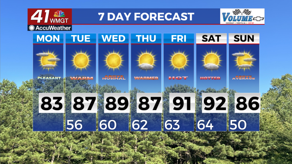
new week. Expansive surface high pressure spreading westward from the Atlantic alongside upper ridging keeps temperatures well above normal today. High cloud cover today will help to keep highs a few degrees cooler than yesterday, although most areas will still top out in the 80s. A strong ridge is building up from the Gulf across the Southeast U.S. keeps very warm and dry conditions in place throughout the upcoming week. This persistent weather can be attributed to an Omega-Block pattern developing, with deep troughing on both sides of the ridge. Dry air from the mid to high latitudes wrapping around the east side of the ridge will keep the chances for rain to near zero. The one exception to this could be late Thursday as models continue to have a shortwave pushing across the Midwest and Tennessee Valley. Rainfall chances with this feature will depend on how strong it is as it crashes into the ridge, but for now it looks like a slim chance for showers in far Northwest Georgia. The overall low rain chances this week will only worsen our ongoing drought conditions, with the low moisture likely leading to daily fire weather concerns. High and low temperatures during this period will likely end up around 12 to 20 degrees above normal. This translates to high temperatures in the 80s to low 90s from Tuesday through Saturday. Daily records could be tied or broken. Overnight lows will likely only drop to the low to mid 60s.