
A cool start to the new week
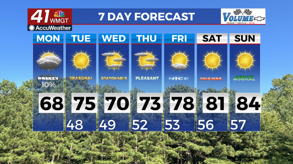
MACON, Georgia (41NBC/WMGT) – A cold front has pushed through and as a result, skies will gradually clear and temperatures return to normal levels for most of the area. Gusty conditions will linger through the day until the front pushes off and high pressure settles in over the area. That process pushes in quiet dry conditions, and the potential for critical fire weather conditions


through the middle of the work week. As the extended forecast period begins, a mid-level ridge moves across the Southeast. Meanwhile, a strong high will transverse the southern Great Lakes and advances towards New England. Within this pattern, clearing skies and continued dry conditions are expected on Tuesday. Lows Tuesday morning will be in the 40s and low 50s. Due to the influence of this ridge, afternoon highs will slightly warmer than today, in the low 70s across the far northern tier and in the mid 70s elsewhere across the area. Dewpoints will remain in the mid 30s to low 40s, which will result in relative humidity values dropping to between 25 to 35 percent in the mid to late afternoon. Locations in East-Middle Georgia could further drop below 25 percent for a few hours. Northeast winds between 8 to 12 mph are anticipated. Given the potential for these conditions, a Fire Danger Statement could be issued considering drying fuels and ongoing drought conditions. On Wednesday, the high will be centered near New England, with a cold air damming wedge developing along the leeside of the Appalachians and overspreading much of the forecast area. Winds within the wedge are expected to be east at 12 to 15 mph with gusts up to 25 to 30 mph. Temperatures will also reflect the wedge with temps in the mid to upper 60s. Temperatures will begin to moderate on Thursday as another more broad ridge sets up over the eastern U.S. rising into the low to mid 70s. Temperatures will continue rising through the end of the week, although the extent of how much will depend on the strength of this ridge.