

Roller coaster temps continue, along with a Fire Weather Watch kick off the weekend
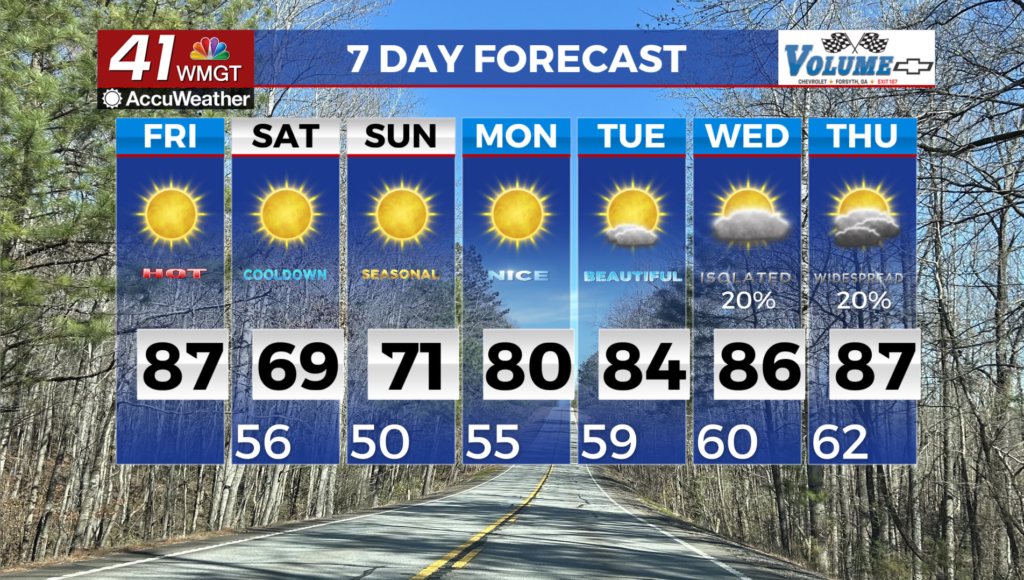
MACON, Georgia (41NBC/WMGT) – The main concern of our forecast comes overnight Friday into Saturday. A dry cold front is set to sweep through much of the south, bringing with it some 


extremely dry air. Relative humidity will fall below 20 percent for much of the viewing area and northwest winds could gust as high as 25 mph. This will present some dangerous fire weather conditions to the area already facing historic drought conditions. Temperatures are expected to drop overnight Friday into Saturday. Lows will be in the upper 40s and low 50s with highs on Saturday back into the 60s, which is a few degrees below where we should be for this time of the year. A very dry airmass advances southward across the Central U.S. at the tail end of the short term period and will situate across the region on Saturday and Sunday. Relative humidity will drop into the teens to lower 20 percent range during the afternoon on Saturday. Coupled with gusty northeasterly winds, a Fire Weather Watch has been issued for our area. Dewpoints are expected to increase on Sunday as winds turn more easterly, however, minimum relative humidity in the lower to mid 20 percent range across parts of North Georgia are likely. The weak cold front associated with this dry airmass will bring temperatures back to near-normal over the weekend. A gradual warming trend returns on Monday, with highs in the lower to mid 80s on Tuesday and Wednesday.