
Dry and cool conditions return but not for long
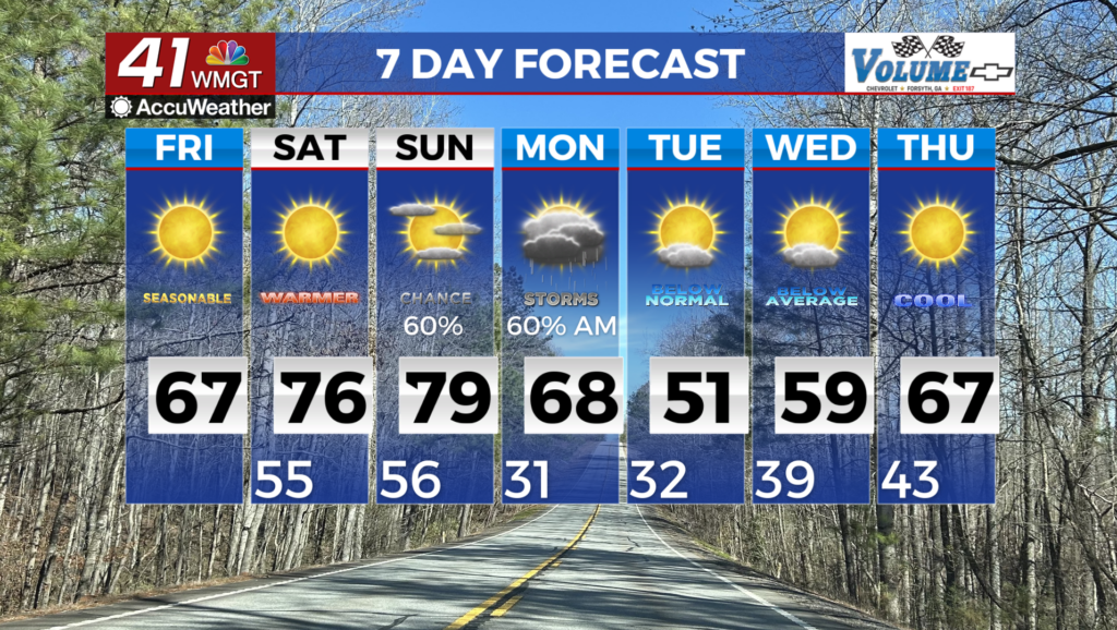
MACON, Georgia (41NBC/WMGT) – A Frost Advisory is in effect until 11 AM today. A pleasant day on tap with highs in the mid 60s across much of the region and dry and sunny conditions 


in place. For Saturday, temperatures rebound over the weekend with highs returning into the mid 70s. This will not last long as our next trough charges in Sunday into Monday, bringing a robust cold front to the region. Expect showers and thunderstorms to spread out over the south through the day Sunday becoming widespread by Monday morning. Showers clear out quickly Monday afternoon ushering in significantly colder air. Temperatures may drop quickly enough to see some mixed rain/snow in the higher elevations of North Georgia, however, no accumulations are expected. Highs on Monday will struggle to climb above the mid 50s across northeast Georgia and lows by Tuesday morning will be in the upper 20s to low 30s. Highs on Tuesday and Wednesday will be in the 50 to 60 degree range with lows holding in the upper 20s to upper 30s. We are slow to recover through the end of the forecast period, especially when it comes to the speed at which the trough moves out of the region.


