
Another unseasonably warm day ahead of the rain
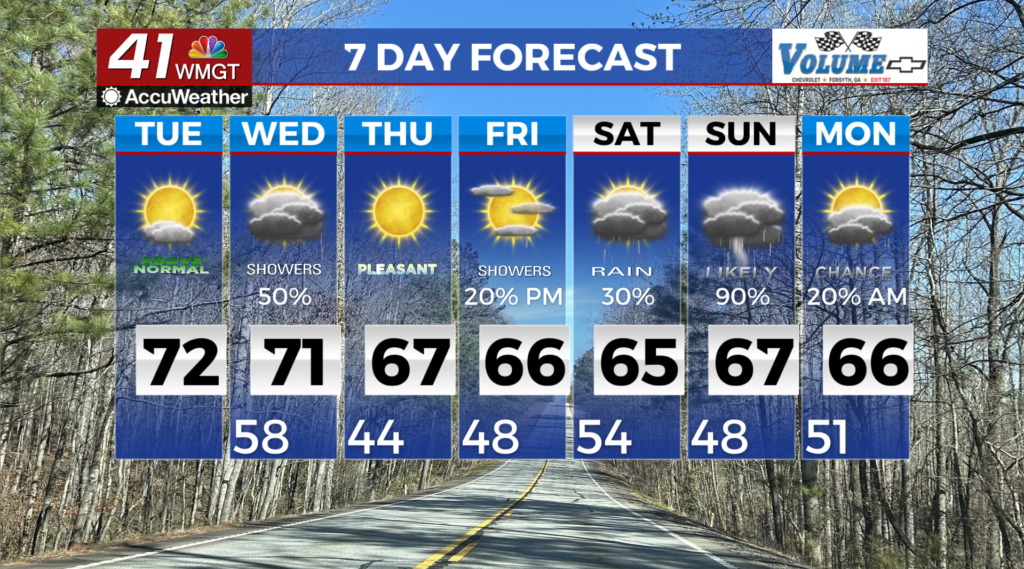
MACON, Georgia (41NBC/WMGT) – We are under the influence of southwesterly flow that is rounding the northern edge of a high pressure system that’s situated across Florida and the Gulf. Middle Georgia continues to trend on the warm side. Moisture will support the development of patchy dense fog this morning primarily for areas to the south and west of the I-20 and I-16 corridors. Any fog that forms will lift and scatter by mid-morning, so do exercise caution during your commute. Highs this afternoon will be in the upper 60s to 70s areawide. This is at least 10 to 20 degrees above average. 


The combination of warm, moist winds and increasing stratus clouds will lead to much warmer lows, in the 50s to near 60, on Wednesday morning. Expect showers to develop overnight tonight into Wednesday morning ahead of an approaching cold front, lingering into the evening as gradual clearing occurs from northwest to southeast. Rainfall totals will remain light, with up to a half inch possible. Highs will be a tad bit cooler along and north of the I-20/I-85 interchange, topping out in the 60s. Areas further south, will likely see the low to mid 70s. By Wednesday evening, rain will have for the most part pushed south of the area with only lingering light rain showers over far Middle Georgia as the front continues to push southward. The bulk of the accumulations will be during the day Wednesday. We could see gusty winds up to 20 to 25 mph across the area Wednesday afternoon and evening following the rain. Ridging will still be the main focus for the latter half of the weekend which will contribute to temperatures continuing to top out in the mid to upper 60s. Ridging turns to more zonal flow before Friday when we begin to see the next low pressure system form over the four corners region. Into Saturday we should see this system move east before fully entering our area on Sunday which will lead to widespread rain chances.


