Rain arrives late, then a quick cool down for Middle Georgia
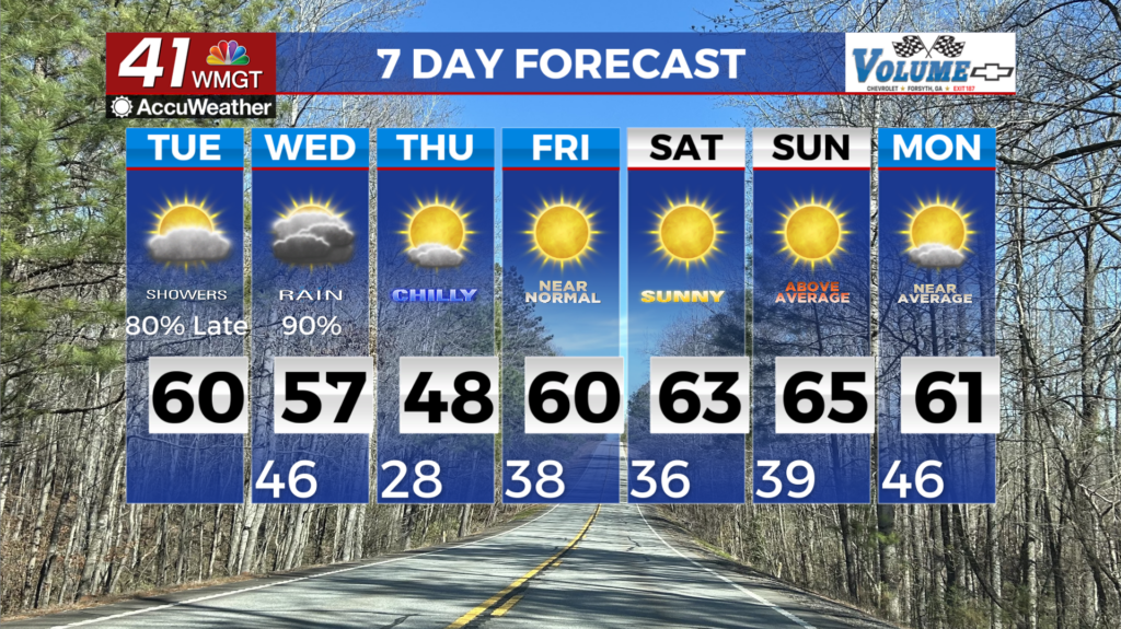
MACON, Georgia (41NBC/WMGT) – A quiet and cool start to the day in north and Middle Georgia with mostly clear skies, light winds, and morning lows in the upper 20s to low 30s. Temperatures will then soar into the mid to upper 50s in North Georgia and low to mid 60s in Central Georgia, by this afternoon, as southwest flow strengthens and brings a warmer airmass 


into the region. This flow develops in response to a midlevel shortwave and frontal boundary that will be dropping across the lower Midwest into the Tennessee Valley throughout the day. By late afternoon, moisture pooling out ahead of the frontal boundary will bring increased clouds with widespread light rain moving into far Northwest Georgia. This will slowly spread across the rest of North Georgia during the evening and overnight hours, continuing across Middle Georgia through Wednesday afternoon. Overall rainfall totals will range from 0.10 to 0.25 inches, with 0.75 inches possible in the Georgia mountains. Despite the rain, the warm and humid airmass will keep temperatures mild tonight and Wednesday, generally ranging from the mid 40s to mid 50s. The actual cold front will start to push across the region Wednesday afternoon and evening, with a dry and cool airmass rapidly filling in behind it and ending any rain chances. As the cold front moves the rain out late Wednesday, cold air filters in behind it. Widespread temperatures below freezing are expected for Wednesday night into Thursday morning, with breezy northwest winds dropping wind chill values into the teens to low 20s. Once that passes through, it’ll be quiet weather for a little while.