Winter storm moves north, but Middle Georgia isn’t in the clear
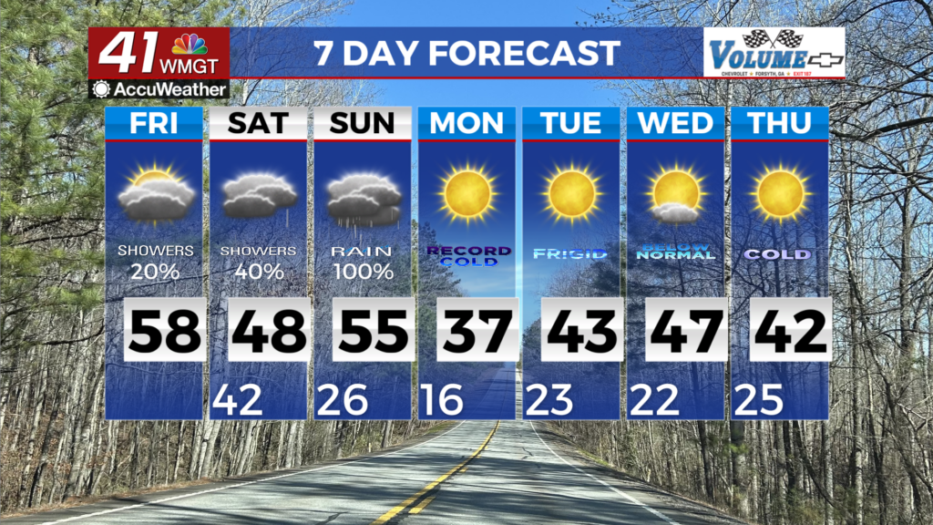
MACON, Georgia (41NBC/WMGT)- Quite the temperature difference is expected today across the region with forecast highs in the 40s across North Georgia and forecast highs in the 60s 


across Middle Georgia. This is indicative of a front across the area, with moisture driving in light rain this morning. Cloudy conditions will persist all day, with light rain becoming more isolated as drier air moves in. Saturday marks the beginning of the impending winter storm. Moisture will start to flow into a cool, dry airmass courtesy of an Arctic high pressure system nudging in from the north and developing a wedge or cold air damming moving in from the east. Models depict saturation of the snow growth zone (that part of the atmosphere where ice crystals are formed) with drier air. The result will be a mix of precipitation types both frozen and liquid across North Georgia in the early to mid-morning. This will be before temperatures warm to above freezing during the late morning to mid-afternoon. As precipitation falls into the developing wedge across Northeast Georgia in the late afternoon, sleet and ice/freezing rain accumulations begin. The primary change to our forecast was the issuance of an Ice Storm Warning for several counties. The portion of the Winter Storm Watch now includes Baldwin, Butts, Hancock, Jasper, Jones, Putnam and Washington counties. These areas may experience power outages and treacherous travel conditions by Sunday morning. We can expect moderate to heavy precipitation during this period. Therefore the extent and intensity of the ice storm will be dictated by the strength of the wedge. A powerful high over the Great Lakes and a developing low along the Carolina coast ensures that a strong wedge will be in place Saturday night across most of North Georgia. This will also help to keep temperatures below freezing within the core of the wedge leading to extensive ice accumulations by Sunday morning. This is a multi-faceted system. As the low moves into Georgia on Sunday, there could be a surge in temperatures just south of Macon (possible temps in the upper 60s to low 70s) while Northeast Georgia could be in the 30s Sunday afternoon. After all of this precipitation moves out, an Arctic front surges through Georgia late Sunday night. This could usher in sharply falling temperatures, the potential of downed trees and power lines, especially in areas that receive significant icing.