


A foggy and warm start to the work week
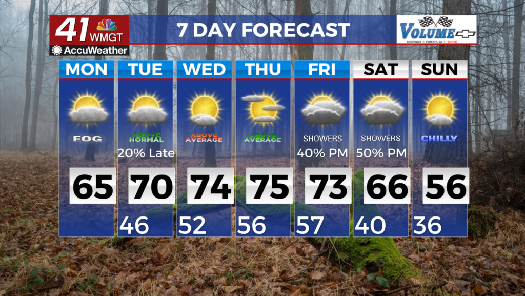
MACON, Georgia (41NBC/WMGT) – Dense fog has developed over the eastern portions of the area. This will last to about 10 am for visibilities of at least 1/4 mile or less. Westward expansion 


 into metro areas is possible but because of the high cirrus clouds that may affect development. Allow yourself a little extra time and care when driving during your morning commute. The fog will likely dissipate around 10 or 11 am however, overcast conditions are likely to hang around in some areas throughout the day. Temperatures will reach the low 60s across the area with close to 70 in Middle Georgia, keeping the trend of above normal temperatures. Tuesday morning, could see fog development again but overall expect cloudy conditions to continue through Tuesday evening. Lows Monday night will slightly dip into the mid 40s with highs Tuesday back into the upper 60s. Winds should remain light through Tuesday evening and other than fog and warm temperatures, an overall uneventful weather pattern is expected through Tuesday evening when it comes to rainfall. Models remain in agreement through most of the first half of the week with the main pattern defined by ridging across the Gulf states. The coverage area will be receiving mostly downstream flow from the ridge as a weak shortwave traverses the Great Lakes region weakening the ridge. This may trigger a few spotty showers given the moist and warm conditions. Temperatures will be well above normal, approximately 15-20 degrees above normal, with highs around 70 across the region. The next real chance for precipitation comes at the end of the week as the ridge moves eastward and amplifies ahead of a western trough.