A brief warm up, then frigid temperatures for late Sunday and Monday
MACON, Georgia (41NBC/WMGT) – Dry conditions over the next day or two. Upper level flow will be out of the northwest as a broad upper level trough traverses the region. Mostly clear 


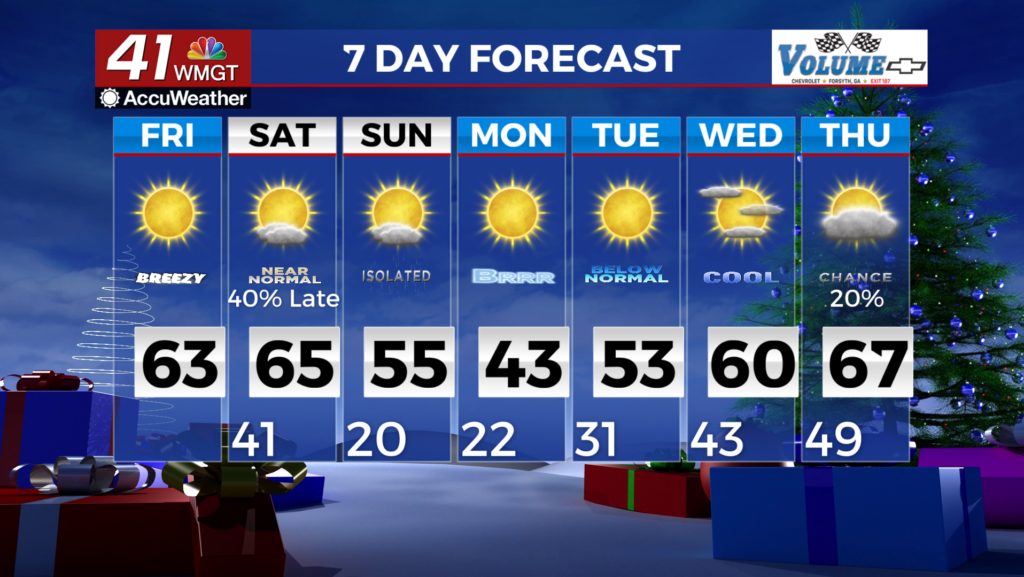
 conditions and drier air means temperatures will fall quickly overnight with lows this morning in the crisp 30s. Highs each day will rebound quickly, given the clear and dry conditions as well as decent low level southwesterly flow. Conditions don’t change a whole lot going into the weekend. A shortwave feature riding the subtropical jet may be enough to prime some moisture ahead of our next system with some weak and very brief southwesterly low level flow. Any moisture that does make it’s way into the area will be shallow. For Saturday night, a closed low will be moving southeastward through the Great Lakes region, with troughing on the southern side swinging through the Eastern U.S. As this occurs, an associated low over Southeast Canada will extend a cold front through the Midwest and into the Tennessee Valley. Isolated to scattered showers are forecast to spread into northwest Georgia on Saturday night. As the front advances southward into the area, scattered showers will overspread much of the area after midnight and through the morning hours on Sunday. As this front pushes through, we will see temps begin to dip into the upper 20s and low 30s over far north and northwest Georgia in the early morning. Rains chances are expected to diminish with the front weakening as it moves south and east into Middle Georgia during the daytime. Rain chances and totals are expected to be highest across the western portions of the forecast area. As the trough clears Georgia to the east and the front exits the area, an Arctic surface high will move towards the Southeast. There is the potential for significantly colder air to set up late Sunday into early next week in association with this high. The extent of how much temperatures will drop will depend on the movement of the high’s center and the proximity of North/Central Georgia to the core of the coldest air. Recent model runs have been consistent in indicating the high’s center will track across the Tennessee Valley region early Monday, and towards the South Carolina/Georgia coast by early Tuesday. This setup favors a greater drop in temperatures by early Monday morning. Low temperatures on Monday morning are expected to drop into the teens in north Georgia and low 20s in Middle Georgia. Wind chills could drop into the single digits in the higher elevations of far northeast Georgia. Monday will be a brisk day throughout, with highs being limited to the low 40s across most of the area. Low temperatures for Tuesday will still be well below normal, in the low 20s across much of the area. Highs will then rise into the upper 40s to low 50s in far north Georgia and mid 50s in Middle Georgia.