
A frigid start to the work week
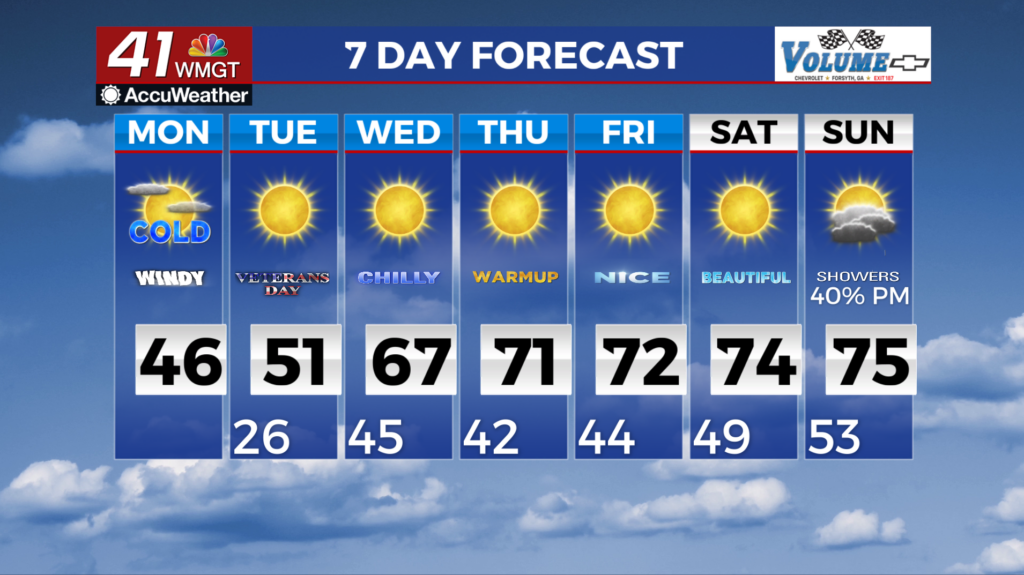
MACON, Georgia (41NBC/WMGT) – The cold air has arrived into the air with some moisture associated with a surface low as it tracks closer. As a result flurries or snow showers are possible in 


 the higher elevations where temps are more likely to line up with the moisture areas. Don’t be surprised if you see very light flurries reaching past the north Georgia mountains, but overall still no impacts are to be expected. The bigger story remains the coldest air of the season pushing into the area. A freeze warning has been issued for overnight tonight into tomorrow morning for the northern portions of the area where temperatures will reach into the upper 20s to low 30s. Daytime high temperatures will top out at 20-25 degrees below normal in the mid 30s to low 40s over much of the area. Pushing into Monday night into Tuesday morning a freeze watch has been issued for the entirety of north and Middle Georgia where temps are expected to reach into the 20-27 degree range with teens possible in the mountains. This is considered a hard freeze and will kill any unprotected vegetation, ending the growing season. Dry air filters in behind Monday’s front, and we will slowly see a steady rise in temperatures. Afternoon high temperatures are expected to fight their way back up into the low 70s by the end of the work week. Overnight lows are expected to remain close to freezing until Wednesday before steadily rising as upper level flow becomes more zonal and we get a slight increase in moisture.