
Dry and warm conditions through Friday
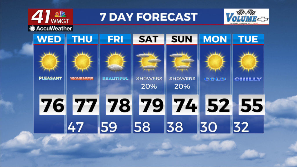
MACON, Georgia (41NBC/WMGT) – Zonal flow and high pressure will dominate through the rest of the forecast period. Overall, a seasonably cool morning is underway with lows in the lower 


 to mid 40s. Little to no high cloud cover will allow for plentiful sunshine and afternoon highs in the 70s. After a slightly warmer day than yesterday, expect overnight to early Thursday morning lows to be a couple degrees warmer than this morning. Thursday will be very similar day weatherwise as today — sunny and dry with highs in the 70s. Friday starts off with continued warm and dry conditions, with high temps climbing to the mid to upper 70s across most of the area. Conditions will abruptly change by the evening hours as an upper level shortwave drops across the Midwest and Ohio/Tennessee Valleys, bringing along a decent plume of moisture with it. Clouds will slowly start to filter in during the afternoon out ahead of this system, with scattered to numerous showers, and even a few rumbles of thunder. This will start to push into West/Northwest Georgia in the late evening hours and gradually fall apart overnight. With a bit of a lull in the pattern, Saturday look like it will remain warm and mostly dry, with only a few showers possible due to lingering moisture. For Sunday, confidence continues to grow in the large-scale pattern rapidly amplifying as deep troughing develops over the Eastern U.S. A leading shortwave and associated frontal boundary look to slide across the Southeast U.S. during the day on Sunday, supporting isolated showers and starting to usher in some cooler air. High temps will range quite a bit across the area on Sunday, with low to mid 60s across North Georgia, and mid to upper 70s across Middle Georgia as the front is unlikely to make it that far until later in the day. Temperatures start to cool off pretty quickly behind the front on Sunday night as the coolest airmass of the season starts to move in. Overnight lows will be around to below freezing across much of North Georgia, with mid to upper 30s in Central Georgia.