
Gloomy, wet, and raw conditions start the new week
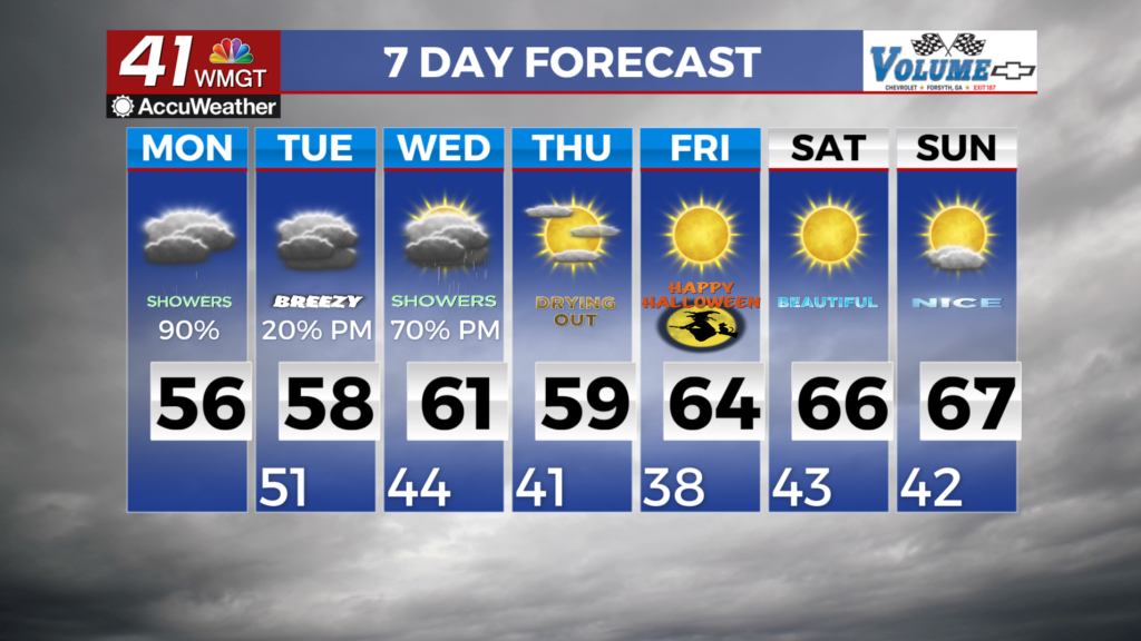
MACON, Georgia (41NBC/WMGT) – For Monday morning, most of North and Middle Georgia will see gloomy, wet, and breezy conditions as a plume of moisture centers itself over the state, 


and a closed low sits just to the northwest. Rounds of widespread showers and a few thunderstorms will be around throughout much of the day as the low slowly slides east across the Tennessee/Georgia border. High temperatures will struggle to climb above the mid 50s given the dense low cloud cover and shallow cool airmass in place. Rain chances will slowly start to drop off from west to east throughout Monday night as the mow moves off to the east. The severe weather threat will be low due to a lack of instability, however, we could see some gusty winds from the strongest showers or storms. Another potential concern through this period, although a low risk overall, is for isolated flash flooding to occur if moderate to heavy rain repeatedly moves over an area. The highest risk for this (again a low risk), would be in the higher terrain of far north Georgia where the highest rainfall amounts are expected. Overall, the rainfall from this event will finally provide some relief to drought-stricken areas, as most of North Georgia can expect a soaking 1.5 to 2.5 inches of rain through Monday night. While totals will be lower in Middle Georgia, most areas can still expect a much needed 0.75 to 1.5 inches of rainfall. After the soaking rainfall, a lull in the rain is expected on Tuesday. With that being said, we cannot rule out some isolated light showers on the backside of the exiting shortwave trough in the short term. High temperatures will be in the mid-50s to lower 60s under a cloudy sky.