
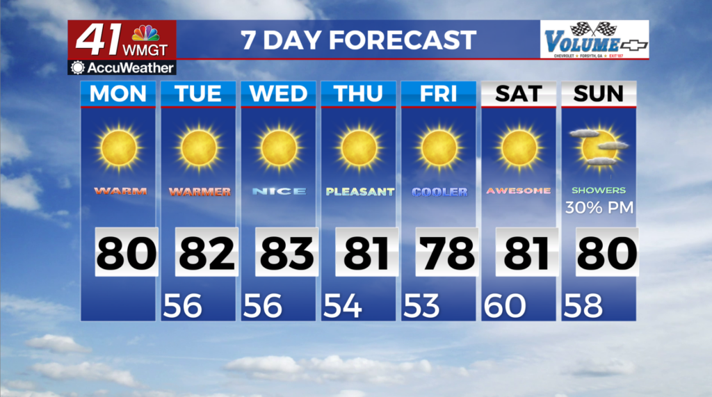
A gradual warm up starts the new week
MACON, Georgia (41NBC/WMGT) – The coastal low has weakened and has lifted towards the northeast on Monday. As this occurs the eastern edge of an upper level ridge centered over Texas 


 creeps into Georgia. This ridge takes firm control of our weather for the rest of the work week, and it will be the harbinger of warming temperatures. Widespread high temperatures will be in the lower 80s Monday afternoon. This will be 3 to 8 degrees above seasonal averages. No rainfall or severe weather is expected in North and Middle Georgia today. A mid-level ridge will be taking residence across much of the Central U.S. and extending towards the Southeast. This set up persists through most of the week promoting the continuation of warm, dry weather across North and Middle Georgia. Daytime highs will range from the upper 70s to the mid 80s from Monday to Friday. Expect temperatures to be 5-10 degrees cooler in the northeast Georgia mountains. Overnight temperatures remain on the cooler side with values in the 50s (40s in the mountains). Between Thursday and Friday, midlevel ridging slides eastward and a surface high becomes wedged up against the Appalachians. So it may be a few degrees cooler Thursday night and on Friday. Rain may be a possibility sometime over this next weekend as another midlevel trough tracks across the Plains towards the Southeast. Any measurable precipitation appears unlikely at this time. Given the lack of appreciable rainfall in the long term forecast, drought conditions are likely to remain the same or worsen.