
Breezy winds and cooler temps end the week
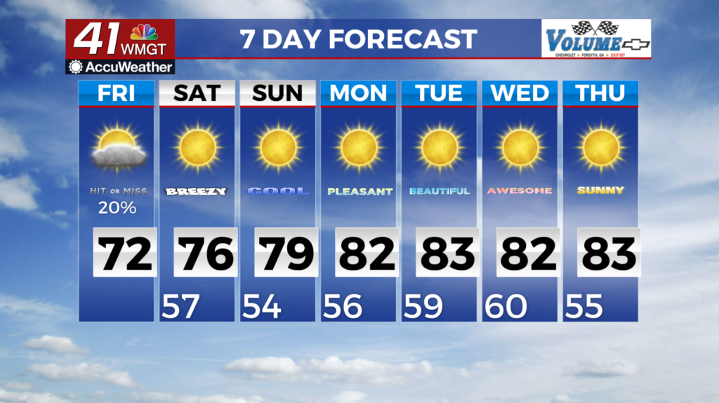
MACON, Georgia (41NBC/WMGT) – Friday will be the coolest day of the week with afternoon high temperatures in the low 70s for most areas. Gusty winds will also be the main story with gusts 


 up to 20 mph expected through at least Saturday. Any meaningful rainfall across North and Middle Georgia appears unlikely over the next 7 days. Mid to upper troughing will still be present over the southeast although hugging the coastline at the start of the forecast period. As this feature shifts eastward, ridging will take up residence across much of the Central U.S. and stick around through at least mid-week next week. The strengthening of this feature will lead to a gradual rise in daytime temperatures each day. Daytime highs will start off in the mid 70s on Saturday warming to the mid 80s Monday through Wednesday. Expect temperatures to be 5-10 degrees cooler in the northeast Georgia mountains. Overnight temperatures will follow suit, starting off in the upper 40s to low 50s rising to the 60s next week. According to the latest 6-10 day precipitation outlook, it indicates a roughly 40-60% that precipitation will be well below normal for North and Central Georgia. Given the lack of rainfall in the forecast, drought conditions are likely to remain the same or worsen.