A pattern shift brings storms and cooler temperatures
MACON, Georgia (41NBC/WMGT) – A frontal boundary is approaching Georgia, and will bring with it instability and moisture. Periods of widespread rain are expected tonight through the end 


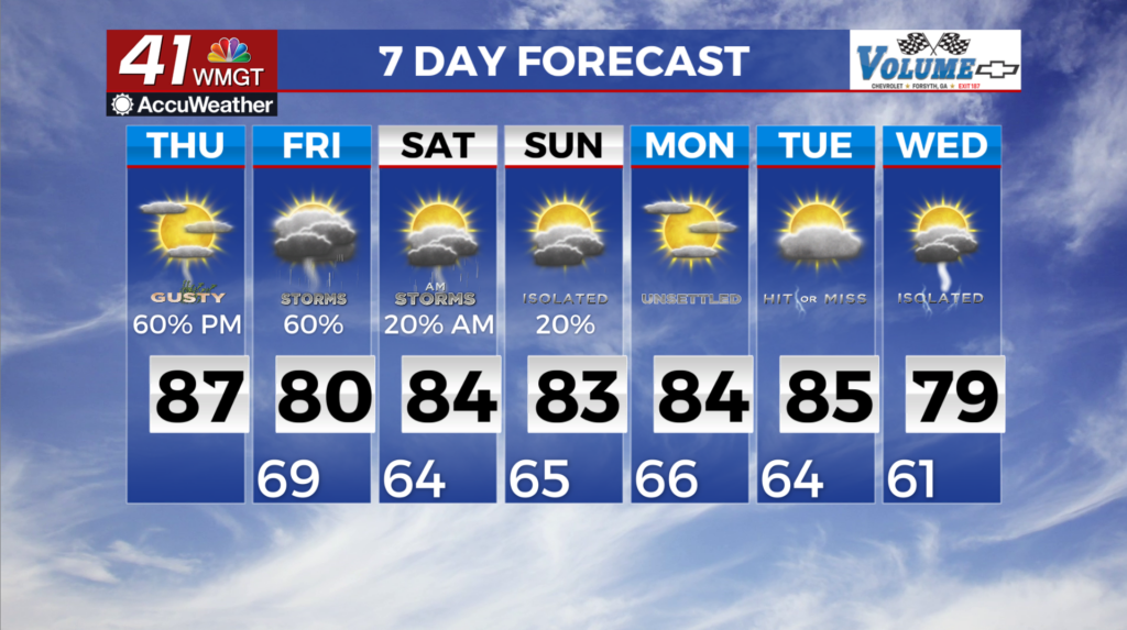
 of the short term period. Rainfall totals are going to range between 1 – 1.5 inches. Isolated higher amounts are possible, particularly over north Georgia, with up to around 3 to 4 inches possible. This afternoon, shower activity is likely. Overnight tonight, additional moisture moves in. Showers and periods of rain are likely over northern and western Georgia. Another surge in moisture, combined with the proximity of the frontal boundary and daytime heating , will result in another pulse in shower activity during the afternoon tomorrow. Scattered to numerous thunderstorms are likely after midday tomorrow into the evening. Some of these thunderstorms are likely to produce strong, gusty winds, and the Storm Prediction Center has issued a Marginal Risk (1/5) for tomorrow. Temperatures will cool off with the arrival of the cold front, which will bring the high temperature Friday back down to near normal levels, in the low 70s to low 80s across northern and Middle Georgia. The long term outlook will be heavily dependent on conditions in the Atlantic over the coming days. A relatively low blocking pattern over the western Atlantic is causing chaos in upstream flow development. The National Hurricane Center has two regions of potential tropical development in the western Atlantic over the next 7 days. Models have continued to try developing at least 1 tropical system (Tropical Storm Humberto) in the area. At the same time, the upper level trough which is bringing our short term precipitation, begins to stall as it runs into the upper level block. The good news is that no model at this time have direct impacts from any tropical system. However, the interaction between 2 (potentially 3) systems is chaotic and adds extreme uncertainty to the forecast beyond the weekend. Any forecast beyond Sunday will likely see significant changes and or uncertainty over the coming days. Generally, with the stalling trough pattern we can expect to see some showers and thunderstorms in the area most days from Sunday forward. Otherwise temperatures should be cooler than they have been with highs in the low to mid 80s and lows in the 60s.