Another day of cool temps before a moderating trend
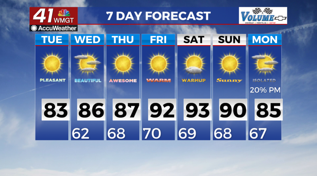
MACON, Georgia (41NBC/WMGT) – A large and somewhat cutoff low continues to meander over the Eastern U.S. today which will help keep a relatively cool and dry airmass in place over much 


 of north and Middle Georgia. A broad surface high over the Appalachians in the northeast and a surface low spinning off the eastern Florida coastline make for a classic wedge environment. We have easterly winds across the area as the cooler, drier air continues to spill into the area from the northeast. Temperatures are on track for the most part with upper 70s and 80s across Middle Georgia. Tonight will see clear skies, calm conditions and radiational cooling. We expect lows near 60 across most of north and central Georgia. On Wednesday, a weakening mid-level shortwave will drop from the Midwest into the Tennessee Valley, along the backside of a deep trough covering much of the Eastern U.S. As the wave approaches the area, low level flow will turn out of the south, bringing in a slightly warmer and more humid airmass. This moisture combined with large scale forcing from the wave will lead to scattered showers and thunderstorms across North Georgia through Thursday. It is worth noting that the latest models have been much less impressive with this wave/moisture than in recent days, so don’t be surprised if rain chances continue to lower. One thing that has remained consistent is that a cold front associated with a strong low pressure system over the Great Lakes looks to push through the region late Thursday into Thursday night. This will bring a dry airmass back into the region for the end of the week and throughout the weekend, with little to no rainfall chances. Temperatures will be right around normal from Friday through the weekend.