
Another hot day then cooler temps for the weekend
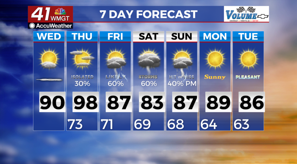
MACON, Georgia (41NBC/WMGT) – As the morning begins, high pressure ridging remains in place along the Appalachians and in North Georgia. Meanwhile, Hurricane Erin is currently about 500 miles to the east of Daytona Beach. Erin will continue northward today, turning towards the northeast and further away from Georgia tonight. No such direct wind or rain impacts from Erin are expected in north and Middle Georgia. Northeasterly low level flow will continue over the forecast area within the weak wedge over north Georgia and on the western side of Erin. Contained in the northeasterly flow is plenty of moisture that will allow dewpoints to be in the low 70s. High temperatures this afternoon will rise into the upper 80s to low 90s. Scattered thunderstorms are expected across portions of north and west Georgia this afternoon, mainly along and north of the I-85 corridor ahead of cold front advancing through the Tennessee Valley region. Locally higher chances will once again be possible in the far northeastern mountains due to terrain influences. A few storms may become strong, with gusty winds from water-


 loading
in downdrafts and along cold pools generated from collapsing storms. Locally heavy rain will also be possible with any stronger storms that develop. Development of additional storms will also be possible along the leading edge of these cold pools. By Thursday, the wedge pattern will erode as the weakening frontal boundary gradually advances south and east into the region. Scattered thunderstorms will be possible once again ahead of the frontal boundary during the afternoon, although the subsidence could once again inhibit coverage in southeastern portions of the region.