More storms possible Saturday; Sunday to see lower odds
MACON, Georgia (41NBC/WMGT) – A weak cold front will spur on scattered storms Saturday afternoon however rain odds Sunday will be lower as it clears the area.
This Evening


It’s been a hot day across Middle Georgia and the evening rain odds have largely not played out to this point. While a shower or storm still do remain possible the odds are much lower than anticipated and things should mainly stay warm and muggy. Overnight lows will be in the low to mid 70s, or a few degrees above average for this time of year. Expect the accompanying wind to be light from the north. Fog will be possible ahead of Saturday morning as well.
Saturday


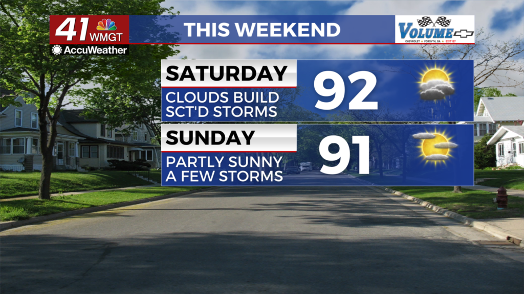
The morning will bring plenty of sunshine before scattered clouds fill in through lunchtime and into the afternoon. High temperatures will climb into the low to mid 90s with heat indexes hovering around 100 degrees once again. The wind will be little help as it stays calm generally from the northeast. Storm odds will climb through the middle of the day and into the evening before tapering off after sunset. Nothing severe is expected however the strongest storms may have respectable gusts.


Overnight will be partly cloudy early before more clearing happens after midnight. Any lingering rain should also taper off not long after midnight. Low temperatures will again be in the low to mid 70s as nights continue to stay above average for mid-August. Wind will be light out of the north-northeast.
Sunday


More sunshine is likely with reduced rain odds through the afternoon courtesy of the weak cold front pushing further south. Highs will reach the upper 80s and lower 90s with heat indexes mainly in the upper 90s. A few triple digit real feels will remain possible. Storms will be limited however a few are still likely through the heat of the day and into the evening. Wind will stay light out of the northeast.
Watching the Tropics


Erin has become a Hurricane and it’s eye is forming heading into tonight. More intensification is expected over the weekend with it possibly becoming a Category 4 Storm on the Saffir-Simpson scale early next week. While a U.S. landfall doesn’t look probable at this time some dangerous effects could still be felt along the East Coast, especially for locations such as the Outer Banks in North Carolina.

Follow Chief Meteorologist Aaron Lowery on Facebook (Aaron Lowery 41NBC) and Twitter (@ALowWX) for weather updates throughout the day. Also, you can watch his forecasts Monday through Friday on 41NBC News at 4, 5, 5:30, 6, and 11 p.m.