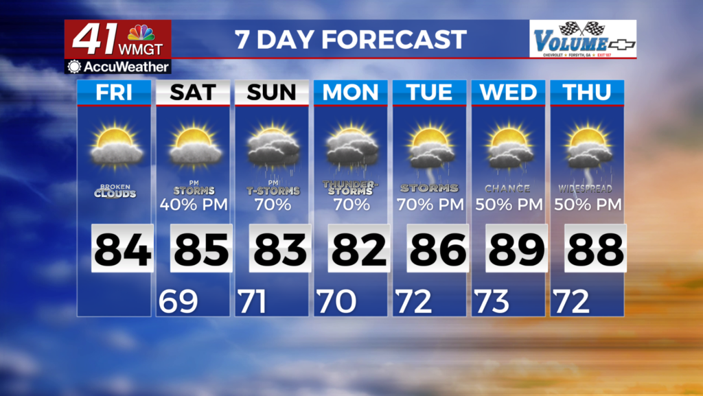
Warmer temperatures will bring increased rain chances
MACON. Georgia (41NBC/WMGT) – Wedge conditions are still in place, however, it has weakened a bit from the past few days. That means temperatures will be cooler than what we would expect 


 for early August with temperatures in the mid to low 80s today and Saturday. Overnight lows are expected to be in the mid to upper 60s. Overall this is more in line with October than August. Rain chances will be limited to northern Georgia, as northeast flow will force what little moisture in the atmosphere to interact with some of the higher points in northeast Georgia. Showers and thunderstorms will be scattered by nature and confined to the Georgia/Tennessee border. Across the southern part of the state, the sea breeze may cause a few storms to pop-up at the far southern end of the coverage area as it interacts with the winds from the wedge combined with the stalled front across Florida. Surface high pressure over the northeast in combination with the potential development of a surface low off the Delmarva will lock in the continued northeasterly flow over the region through the weekend and into next week. Airmass no longer directly tied to Canadian air that brought the very cool air earlier this week, will instead be a bit more modified with Atlantic moisture, and be a bit warmer, allowing an increase in daytime driven convection across the area. Temperatures through this weekend should remain in the 80s across north and Middle Georgia, while afternoon rain chances slowly increase into early next week.