Heat Advisory extended again for Middle Georgia
MACON, Georgia (41NBC/WMGT) – The National Weather Service in Peachtree City has extended the Heat Advisory for Middle Georgia through 8 PM EDT Friday evening.
This Evening


It’s a partly sunny and hot afternoon around Middle Georgia as heat indexes have largely climbed to or above 105 degrees. Isolated showers and storms will be possible through the evening and tonight, however the odds should be lower than yesterday evening. No severe weather is expected, however the most organized storms could have a few respectable wind gusts.


Overnight skies will largely clear of cloud cover as temperatures drop into the low to mid 70s. Wind will be light from the south-southwest. Some patchy fog will also be possible leading up to the sunrise tomorrow morning.
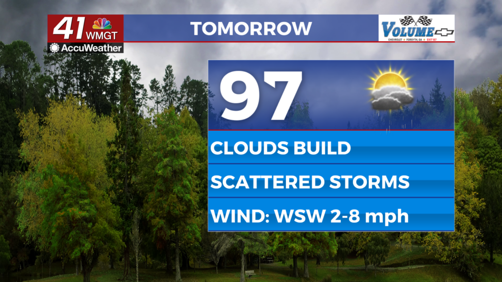
Tomorrow


The final day of the work week will be another hot one as highs are anticipated to climb into the mid to upper 90s with heat indexes again pushing towards/above that 105 degree mark. Wind will be light from the west-southwest at around 5 mph.


An incoming cold front from the north will increase rain odds through the evening and into the night. As a result, expect cloud cover to increase through the lunchtime hours before storms start firing up. A Level 1 “Marginal” threat for severe storms currently encompasses most of Middle Georgia for our Friday afternoon/evening. This is due to the potential for organize storms to bring damaging winds or perhaps some hail.


Overnight will be partly cloudy and muggy with lows expected again in the low to mid 70s. Wind will be light and variable, and rain from the evening will likely continue into the wee hours of the night. Rain should be done ahead of the sunrise Saturday, however.
This Weekend and Beyond


Cloud cover will be more dominant this weekend and the cold front responsible for Friday’s rain will continue to push south, leading to more clouds and cooler temperatures for Middle Georgia. Highs should largely be in the upper 80s Saturday with real feels into the upper 90s, while Sunday will see highs in the lower 80s and near overcast conditions. Both days this weekend will have good odds for rain, especially Saturday. The cooler and wetter pattern will carry into the start of next week.

Follow Chief Meteorologist Aaron Lowery on Facebook (Aaron Lowery 41NBC) and Twitter (@ALowWX) for weather updates throughout the day. Also, you can watch his forecasts Monday through Friday on 41NBC News at 4, 5, 5:30, 6, and 11 p.m.