Winter weather expected tomorrow morning
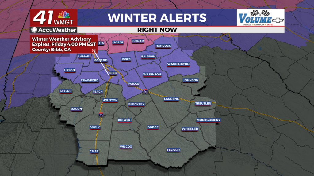
MACON, Georgia (41NBC/WMGT) – All modes of winter precipitation are possible to begin the day Friday for parts of Middle Georgia.
This Evening and Overnight


Clear skies from the afternoon will see clouds move in through the overnight hours tonight. It will be a cold night as temperatures are expected to go below freezing, however it will not be as cold as the past two nights and faucets will likely not need to be dripped. As humidity climbs through the overnight hours the odds for a couple of isolated snow showers will grow. Lows will likely be not long after midnight as temperatures are expected to slowly climb heading through the morning thanks to a warm front.
Tomorrow Morning


Temperatures will be below or around freezing as the morning begins, resulting in any precipitation being icy to start the day. Sleet and freezing rain will both be possible as snow showers shift to rain in the late morning. Roads may be icy early, however temperatures will climb above freezing ahead of lunchtime. This will lead to a shift to rain and that is the way precipitation will stay the rest of the day. Highs will range from the upper 30s into the mid 40s in the late afternoon/evening. Wind will generally flow from the east, gusting upwards of 25-30 mph.
Tomorrow Night and This Weekend


Rain will continue Friday night before clearing out ahead of Saturday. Temperatures should remain above freezing overnight Friday for most of the region, so roads are unlikely to freeze back over ahead of Saturday morning. The northernmost counties may be an exception.


Expect mostly cloudy and windy conditions on Saturday with highs in the mid to upper 40s. Sunday will be calmer and should see some more sunshine.

Follow Chief Meteorologist Aaron Lowery on Facebook (Aaron Lowery 41NBC) and Twitter (@ALowWX) for weather updates throughout the day. Also, you can watch his forecasts Monday through Friday on 41NBC News at 4, 5, 5:30, 6, and 11 p.m.