
Monday Weather Roundup: Tornadoes confirmed from yesterday and freezing cold tonight across Middle Georgia
Sunday Tornadoes:
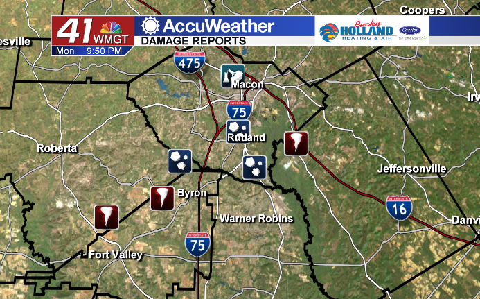
Several tornadoes were confirmed today by the National Weather Service. We are still waiting on the official survey,so these are just preliminary confirmations. The Crawford/Peach County tornado started as an EF2 (114mph) and weakened to an EF1 before reaching Byron. There was also a confirmed tornado in Twiggs County near Huber. This is expected to be categorized EF1.
Winter Weather:

Overnight tonight we are seeing some moisture move in across the area. This combined with the quickly cooling air in Middle Georgia will lead to the possibility of some sleet and maybe even a few snowflakes mixing in with rain. No accumulation are expected, and we shouldn’t see much impact.
This Week:
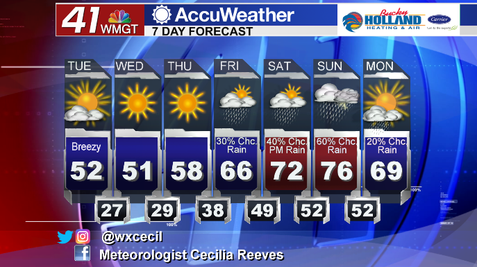
Through this week we will be staying cold (lows stay in the 20’s through Thursday AM), but mainly dry after this rain/mix gets out of here tonight. Over the weekend we will finally make it back to the 60’s and 70’s, but rain chances are back as well as the potential for another Sunday with storms that could be strong to severe. We will keep monitoring the forecast for more severe weather potential.

Leave a Reply