Preparing for the impacts of Idalia
MACON, Georgia (41NBC/WMGT) – Hurricane Idalia is barreling its way towards Florida and Southern Georgia, and parts of Middle Georgia will see more impacts from the storm than others.
Today


This afternoon and evening will see a number of scattered thunderstorms around much of the Peach State as the stalled out front continues to hang around. High temperatures will reach the upper 80s for most of the region with heat indexes into the upper 90s. Winds for today will remain out of the southeast at around 5 mph, however stronger gusts could be possible with storms. No severe weather outlooks have been issued for this afternoon/evening.


Tonight off and on rain may continue as lingering storms from this evening fade out and outer rain bands of Idalia come into the region from the south. Winds will shift to the east-northeast ahead of tomorrow morning, however the speed shouldn’t increase much overnight. Temperatures to begin Wednesday will be in the lower 70s once again around the region.
Tomorrow


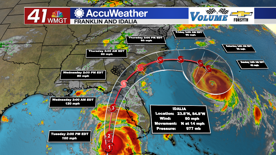
It will be a wet day across Middle Georgia as Idalia passes through South Georgia for much of the day Wednesday. The southeastern counties of the region will see the largest impacts from the storm. While a city like Macon will likely see sustained winds of 10-20 mph and gusts 30+ with forecast rain totals of 1-3 inches, a city like Dublin could see 30+ mph sustained winds and gusts pushing 60+ mph with 3-6 inches of rain (with locally heavier amounts possible). Added to rain brought in Tuesday afternoon and evening much of Middle Georgia could see a flooding/flash flooding risk on Wednesday. A couple of brief spin-up tornadoes could be possible further away from the storm’s center. This would include cities like Macon, Forsyth, or Milledgeville. Travel around the region is not advised tomorrow, however effects should not be drastic enough to call for evacuations. That being said, strong winds will likely lead to downed trees, power lines, and blocked roadways.


Tomorrow night Idalia will move out to the east as it continues to weaken. Skies will remain cloudy early on, however clearer conditions should return ahead of Thursday morning. Temperatures will drop into the upper 60s for most of Middle Georgia with north-northwest winds blowing in at about 10-20 mph.
Thursday and Beyond
Plenty of sun and greatly reduced humidity will stick with Middle Georgia into Labor Day Weekend. In fact, Thursday and Friday will likely see partly cloudy conditions before mostly sunny skies take over more for the holiday weekend itself. Highs should remain below the 90s until Labor Day.

Follow Meteorologist Aaron Lowery on Facebook (Aaron Lowery 41NBC) and Twitter (@ALowWX) for weather updates throughout the day. Also, you can watch his forecasts Monday through Friday on 41NBC News at Daybreak (5-7 a.m.) and 41Today (11 a.m).