


Wet weekend with cooler temperatures
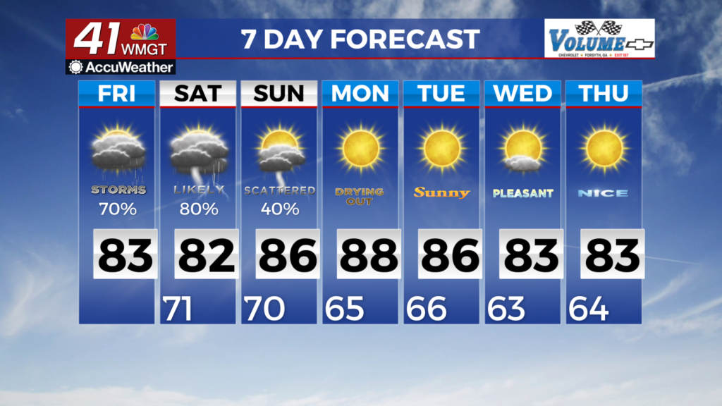
MACON, Georgia (41NBC/WMGT) – We had isolated to scattered showers and thunderstorms that popped up across the area along two boundaries. The first boundary has been stalled across 


 central/south Georgia for a few days with the second boundary over North Georgia moving slowly south through Friday. These storms had a decent amount of lightning with some gusty winds and periods of heavy rain. The northern frontal boundary is expected to reinforce the southern boundary as it stalls across Middle/South Georgia through the weekend. This boundary will bring a deep layer of moisture and some instability with it acting as a catalyst for daytime driven convection. Moisture levels are projected to be high. Combine this with peak heating hours (temps in the 80s and 90s) each day and that sets the stage for strong to severe storms across the area. Temperatures will be near seasonal norms with highs in the lower to middle 80s. Low temps tonight will be in the lower 70s across the region. A stationary front will continue to bring unstable weather to parts of the southeast through the weekend. While severe weather seems unlikely at this time, we will monitor the potential for flash flooding, especially areas along and south of I-20 where the stationary front is expected to stall. Rainfall totals could be anywhere from 1-3 inches with isolated areas up to 5 inches. A strong cold front is set to push the stationary front out Sunday into Monday. The resulting conditions behind it will give us a taste of fall. The first part of next week calls for little to no rain, highs in the low 80s and overnight lows in the 60s. If you’re into pumpkin spice, your time is coming!