


Wet weekend followed by cooler week ahead
MACON, Georgia (41NBC/WMGT) – An approaching front will stall over north Georgia. This front will serve as the focus for shower and thunderstorm development for Friday and Saturday. High 


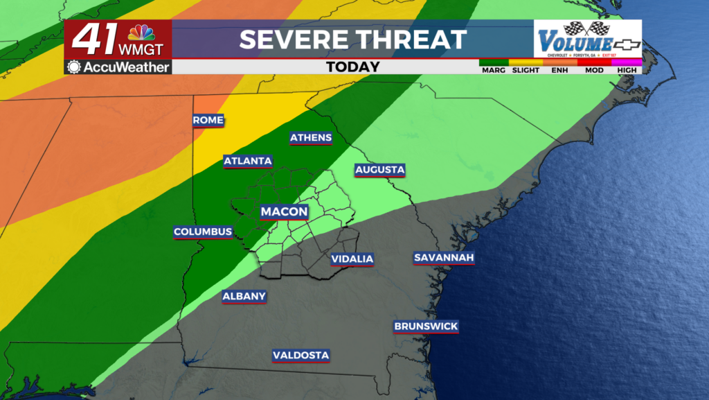
 temperatures today are expected to rise into the 80s across most of the region and into the 70s in the higher elevations of far northeast Georgia. Overnight lows will primarily range from the upper 50s to mid 60s. The Storm Prediction Center has placed a Marginal (level 1 of 5) Risk for Severe weather to the north of I-85 corridor and a Slight (level 2 of 5) Risk in the extreme northwest corner of the state. The primary threats with any severe storm is damaging wind gusts. Thunderstorm coverage is expected to begin to decrease after sunset this evening, though isolated precip could still persist into the overnight and early morning hours. On Saturday morning, the cold front is expected to be just west of the area, moving east, bringing with it an increase in moisture and instability. Showers and thunderstorms are likely to already be occurring with the arrival of Saturday morning, and will likely persist through the day on Saturday. Decreasing moisture and instability is expected on Sunday; lingering moisture could still sustain persisting shower activity. There remains a small risk for thunderstorms on the southeast corner of the region on Sunday afternoon, as well. There remains some uncertainty with how quickly moisture will exit the area. Sunday will be drier than Saturday, with showers and thunderstorms for Sunday afternoon generally limited to eastern/southeastern portions of the area. High pressure building into the region behind the cold front will bring cooler, drier conditions, which will likely last through the first half of next week. High temperatures will range between the mid 60s and low 80s on Monday, with only a modest increase to the upper 60s to mid 80s by Wednesday. Overnight low temperatures through early next week are likely to be in the mid to low 60s.