Wet Start to the Weekend
MACON, Georgia. (41NBC/WMGT) – Isolated showers on this Friday evening will become more widespread overnight tonight.
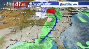
Tonight and Tomorrow.

While the cloudy conditions will stay consistent overnight, expect the coverage and intensity of the rain to increase into the early morning hours. Isolated showers this evening will give way to heavier showers associated with a broad line of rain heading our way. The heaviest of the rain will move in during the early morning hours, but will last into the first half of the day. By the time we get to the early afternoon hours conditions will be improving as the cloud cover decreases and the rain moves away. Once the rain and clouds move out temperatures are going to have a chance to cool into the low-to-mid 40’s.
Sunday.
After a wet start to the weekend we will dry out temporarily on Sunday. Under a partly cloudy sky temperatures will make it into the upper 60’s across Middle Georgia before a cold front moving through overnight Sunday night into Monday morning brings an enhanced chance for some more rain. Rain is expected to be back in Middle Georgia late Sunday night and early Monday morning.
 Next Week.
Once the cold front passes through early Monday morning, a dry weather setup begins for your work week. Clouds will be on the decline behind the front as an area of high pressure builds in from the west. This high pressure system will slide to the east and keep us dry throughout the work week. Temperatures will be near average across Middle Georgia as we head into the last few days of November.
 Connect with Meteorologist Dalton Mullinax on Facebook (Dalton Mullinax 41NBC) and Twitter (@MullinaxWX) for weather updates throughout the day. You can also watch his forecasts Monday through Friday on 41NBC News at Daybreak (5-7 a.m.) and 41Today (11 a.m.).


Leave a Reply