
Wet and soggy start to Juneteenth
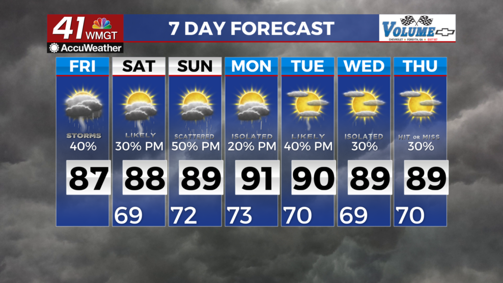
MACON, Georgia (41NBC/WMGT) – The remnants of Tropical Storm Arthur continue to make their way eastward toward Georgia, pushing abundant tropical moisture over the state. Gusts to 25 


to 40 mph are possible. Significant rainfall is expected, with heavy rain or deluges at times, resulting in high rainfall rates and rapid accumulations, which could result in high rainfall rates and rapid accumulations, which could lead to flooding conditions. Rainfall amounts of 1 to 4 inches are anticipated, with locally higher amounts possible. The combination of significant rainfall and strong winds enhances the risk of downed trees. Winds decrease in the morning, becoming west to northwest at around 10 to 15 mph. Showers linger into the morning, and cloudy conditions are 


likely into the midday. Pop-up thunderstorms are possible tomorrow afternoon–less vigorous and less coverage is expected compared to late yesterday and today. To begin the forecast period, a cold front will push into the area with tropical moisture associated with the remnants of Arthur pushing out of the area. This cold front is expected to stall Sunday with increased possibilities of rain likely by Sunday afternoon. Low end rain chances will be possible each afternoon next week as ridging builds into the south. This will promote more humid conditions across the state, with a 
summer-like pattern likely next week. Afternoon convection is likely each day, with afternoon rain chances around 30 to 40 percent. Coverage would not be widespread but more scattered. Temperatures are expected to return to the average or slightly above average as high pressure centers itself just south of the state. Maximum heat index values will return to the upper 90s to near 100 degrees for Middle Georgia and southern locations.