


Warm and dry through the end of the week
MACON, Georgia. (41NBC/WMGT) – Above normal temperatures will hang around Middle Georgia for the foreseeable future.
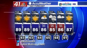
TODAY.

Much like yesterday, we will see a mostly sunny sky with just a few high clouds out there. Temperatures during the afternoon hours will be some of the warmest temperatures that we have seen in 2019. High temperatures today will be in the upper 80’s with a few spots hitting the 90° mark for the first time this year. Temperatures will be in the low to middle 60’s overnight tonight under a mostly clear sky. Patchy dense fog is possible on Wednesday morning so make sure you are taking the necessary precautions if you were to encounter an area of fog.
TOMORROW.
Warm air continues to feed into our region as we will be back in the upper 80’s under a partly sunny sky. Wednesday will essentially be a repeat of today with more high clouds rolling in during the afternoon and evening hours.
EXTENDED FORECAST.

We will cool back down into the middle 80’s towards the end of the week, but rain chances will be back on the rise as we head into the weekend. Friday we will be dealing with isolated showers, but coverage increases on Saturday and then reduces on Sunday.
 Follow Meteorologist Dalton Mullinax on Facebook (Dalton Mullinax 41NBC) and Twitter (@MullinaxWX) for weather updates throughout the day. You can also watch his forecasts Monday through Friday on 41NBC News at Daybreak (5-7 a.m.) and 41Today (11 a.m.).
Leave a Reply