


UPDATE: Tropical Storm Dorian
MACON, Georgia. (41NBC/WMGT) – Tropical Storm Dorian is closing in on Puerto Rico this morning where landfall is expected on the island in the coming hours.
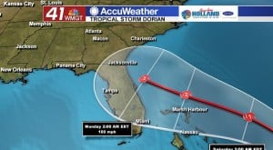
Once Dorian makes it past Puerto Rico, it will be entering warm water where strengthening is expected to occur. The National Hurricane Center’s (NHC) latest update, issued at 8 am this morning, has Dorian strengthening into a Category 2 hurricane before making landfall on the southeast coast late Sunday/early Monday. While the center-line of the forecast cone RIGHT NOW takes the storm into Florida, tweaks in the forecast in the coming days closer to landfall could shift the storm further north or south.
MIDDLE GEORGIA IMPACTS:
With the current NHC forecast, Dorian will bring heavy rain to our area early next week. Gusty winds are likely as well.
FORECAST TRACK UNCERTAINTY:
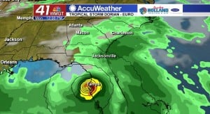
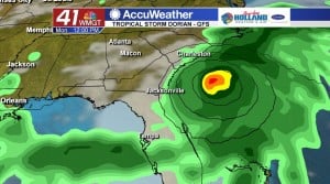
Dorian’s track varies between two of the major global models used to guide forecasts.
- The European model takes Dorian into Florida late Sunday/early Monday and then sends the storm north on Monday/Tuesday into South Georgia. If this scenario plays out, 2-4” of rain in Middle Georgia would not be out of play with isolated areas receiving up to 6”.
- The GFS model tracks Dorian further north. Landfall in this scenario would take place near the Carolinas on Monday/Tuesday. If this scenario plays out, rain totals will be much less in our are.

Leave a Reply