The heat is on for the weekend
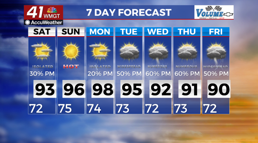
MACON, Georgia (41NBC/WMGT) – Scattered thunderstorms are once again expected. Coverage may not be as widespread as yesterday with a shortwave moving out of the Ohio Valley and a 


 modest ridge on top of the coverage area. No significant airmass changes are expected through Saturday, so we are likely to see the same conditions for Saturday as well. Thunderstorms could produce locally heavy rainfall, frequent lightning, and strong wind gusts. Storm motion will likely be slow, meaning localized street flooding or even some flash flooding cannot be ruled out. While conditions will be hot and humid, temperatures in most areas will feel like 98 to 103 degrees, though some could see 104 to 105 in the southeastern counties. Overall, peak heat index values will be short lived and afternoon thunderstorms could help to moderate temperatures. A subtropical ridge begins to set up over portions of the Southeast and western Atlantic heading into the weekend and staying put through the majority of the long term period. With moisture sticking around this set up will favor hot/humid conditions and daily afternoon and evening thunderstorms. Temperatures are forecast to climb back up into the low to mid 90s, perhaps upper 90s across portions of East-Central Georgia this weekend and next week. Please take necessary precautions if you have outdoor plans!