


Temperatures and humidity increasing
MACON, Georgia. (41NBC/WMGT) – High pressure at the surface will keep most areas dry today, but a few isolated downpours are still expected to form across our area.
TODAY.
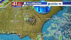
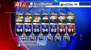
After a weekend where nearly all of Middle Georgia stayed dry minus a stray shower or two, better rain chances are beginning to work their way back into the Peach State. Under a partly sunny sky this afternoon temperatures will top out in the low to middle 90’s. Isolated showers will begin to form this afternoon and slowly drift across the area. Rain chances for this afternoon and evening are running at 20%. As for tonight, we will keep a few clouds around as temperatures fall into the upper 60’s and lower 70’s.
TOMORROW.
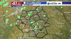
We will essentially hit the repeat button on Tuesday afternoon as isolated showers will once again be back in the forecast. Rain coverage is still limited, but we will begin to slowly see the return of more shower coverage towards the end of the week. Temperatures tomorrow will top out in the low to middle 90’s during the afternoon hours before falling back into the upper 60’s and lower 70’s overnight.
REST OF WORK WEEK.
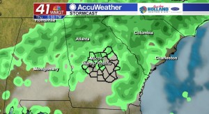
Rain chances begin to increase on Thursday afternoon as showers and a few thunderstorms will become more widespread through the rest of the work week and into the weekend. Our typical summertime pattern is going to return as we leave the lower humidity days of last week and this past weekend behind us.
 Follow Meteorologist Dalton Mullinax on Facebook (Dalton Mullinax 41NBC) and Twitter (@MullinaxWX) for weather updates throughout the day. You can also watch his forecasts Monday through Friday on 41NBC News at Daybreak (5-7 a.m.) and 41Today (11 a.m.).

Leave a Reply