


Temperatures cool down late in work week
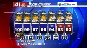
MACON, Georgia. (41NBC/WMGT) – After setting new record high temperatures on Saturday and Sunday we still have the chance to break a couple more records over the next few days.
TODAY.

Under a mostly sunny sky we will see temperatures back into the upper 90’s and near 100° in spots. While rain will not be widespread, an isolated shower or two cannot be ruled out, but rain chances are running at less than 10%. Overnight tonight we will begin to see a few clouds roll in leading to a partly cloudy sky with temperatures in the low to mid 70’s.
TOMORROW.
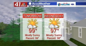
Plenty of sunshine is back in the forecast on Tuesday afternoon as temperatures will be well on their way back into the upper 90’s. The ridge of high pressure that is currently dominating our area and keeping things abnormally hot and dry will stay in place.
REST OF WEEK AND BEYOND.
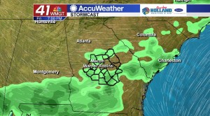
As we get into the middle and later part of the work week we will begin to see a change in our weather pattern. The ridge of high pressure will begin to flatten out, and that means temperatures will cool off into the lower 90’s and rain chances will slightly increase as we head into the week. Right now it just looks like isolated rain chances for the upcoming weekend, but I will continue to monitor that.
 Follow Meteorologist Dalton Mullinax on Facebook (Dalton Mullinax 41NBC) and Twitter (@MullinaxWX) for weather updates throughout the day. You can also watch his forecasts Monday through Friday on 41NBC News at Daybreak (5-7 a.m.) and 41Today (11 a.m.).

Leave a Reply