

A Tale of Two Weather Patterns in Middle Georgia
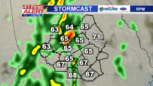
MACON, Georgia (41NBC/WMGT) – Temperatures have trended well above average this week thanks to a warm, moist air mass sitting across the southeast. A ridge of high pressure has moved over the Atlantic Ocean, resulting in winds out of the east/southeast. This wind flow has moved moisture from the Atlantic over the coastal states. For this reason, we have seen a good amount of cloud cover and scattered rain showers this first full week of January.
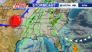
Meanwhile, a low pressure system and associated cold front is firing up more showers and storms in the Midwest. This system will be headed our way on Friday, bringing even more rain to the forecast and another blast of cold air this weekend.
Model trends show a line of showers and thunderstorms entering Middle Georgia late Friday morning through the afternoon. The Storm Prediction Center has not included Middle Georgia in a risk for severe weather, though some of the storms within the line may be strong and contain periods of heavy rainfall and/or strong wind gusts.
The rain should clear our area by Friday evening, leaving some clouds behind into early Saturday morning. The clouds will clear out as drier air pushes in from the northwest. With the sunshine comes much cooler air. Temperatures will drop about 30 degrees from Friday afternoon to Saturday morning.
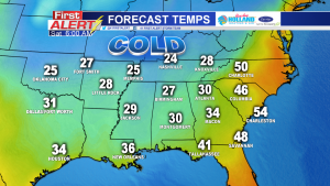
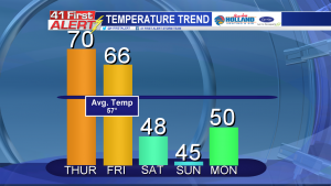
Enjoy what’s left of the warm weather this week, because the cold air returns not only this weekend but also early next week. Temperatures will go from trending about 10 degrees above average to dipping about 10 degrees below average.
As always, you can download our 41First Alert Storm Team app for the 7-day forecast.


Leave a Reply