


Strong storms possible today
MACON, Georgia. (41NBC/WMGT) – A low pressure system approaching the Peach State today will bring the chance for scattered strong to potentially severe storms as we get into the afternoon and evening hours.
TODAY.
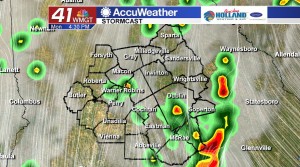
After a mostly quiet weekend across Middle Georgia, weather activity picks up today as an area of low pressure and associated cold front make their way towards our area. It was a warm and muggy start to the day, and that will be the case this afternoon as well. Under a partly to mostly sunny sky, temperatures will soar into the upper 70’s and lower 80’s.
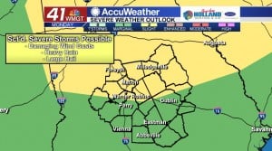
As of 5 am on Monday, April 8, the Storm Prediction Center had parts of Middle Georgia in a slight (level 2/5) risk area for severe storms. The main concerns for scattered strong storms this afternoon will be damaging winds of 40-60 mph as well as the potential for hail.
As we get into the late evening and early night hours after sunset, thunderstorm activity will taper off, but isolated showers will still hang around. Under a mostly cloudy sky temperatures will fall into the lower and middle 60’s.
TOMORROW.
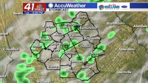
Isolated showers and a few thunderstorms hang around on Tuesday as the cold front clears Middle Georgia. Under a partly sunny sky temperatures will warm into the upper 70’s before falling into the middle 50’s overnight under a mostly clear sky.
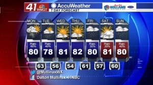
REST OF WEEK & WEEKEND.
High pressure will move into the region on Wednesday and will keep us mostly dry through Thursday night. As we get into the final day of the work week another cold front will sweep across the region bringing a chance for a few showers. Saturday looks to be mostly dry at the moment, but rain chances increase as we get into the latter part of the weekend.
 Follow Meteorologist Dalton Mullinax on Facebook (Dalton Mullinax 41NBC) and Twitter (@MullinaxWX) for weather updates throughout the day. You can also watch his forecasts Monday through Friday on 41NBC News at Daybreak (5-7 a.m.) and 41Today (11 a.m.).

Leave a Reply