

A few showers today, but heavier rain returns tomorrow
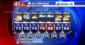
MACON, Georgia. (41NBC/WMGT) – Much like yesterday, we will see a mix of sun and clouds this afternoon as temperatures rise into the 70’s.
TODAY.
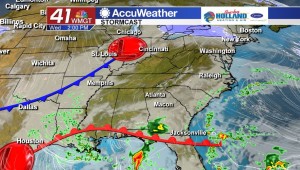
The area of high pressure that kept us dry over the past couple of days has moved off the eastern seaboard, and with that we will see a gradual return of moisture into our area. This morning we started off with a partly cloudy sky, and by the time we make it into the afternoon hours we will begin to see a few more clouds filter into our area. Yesterday we hit a high temperature of 72° at the Middle Georgia Regional Airport, and today we will be warmer as temperatures make it into the middle 70’s. While rain chances are slim, they are not zero. A light shower and a few sprinkles cannot be ruled out as we head into the afternoon and evening hours. Overnight tonight we will usher in a few more clouds as temperatures will be in the low to mid 50’s.
REST OF WORK WEEK.

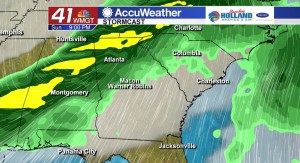
Tomorrow we will see a cold front move through our area, and while temperatures will not be affected by this frontal passage, we will see the chance for a few thunderstorms. No severe weather is forecast at this time, but heavy rain and a few rumbles of thunder cannot be ruled. Temperatures will be back in the 70’s although we will be dealing with a mostly cloudy sky. On Friday, rain chances go down, but there is still the chance we will see a few isolated showers.
WEEKEND AND BEYOND.
If you have outdoor plans this weekend I would suggest completing them on Saturday, because heavy rain returns to Middle Georgia on Sunday. A cold front will move through on Sunday and behind that front we will get another shot of cool air as we head into the first week of March.
 Meteorologist Dalton Mullinax on Facebook (Dalton Mullinax 41NBC) and Twitter (@MullinaxWX) for weather updates throughout the day. You can also watch his forecasts Monday through Friday on 41NBC News at Daybreak (5-7 a.m.) and 41Today (11 a.m.).


Leave a Reply