Showers & thunderstorms increase this afternoon and evening
MACON, Georgia (41NBC/WMGT) – Some showers have redeveloped this morning. Expect areas of low clouds and patchy fog mainly in areas where rain occurred. 
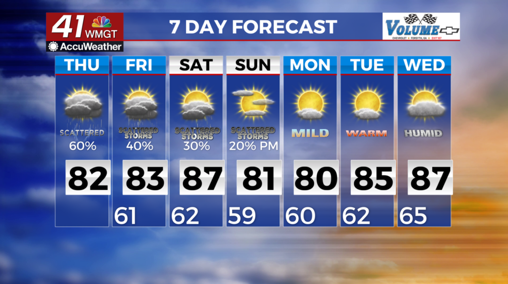
 Our summer-like pattern continues through the long term beginning on Friday. Flow aloft remains weak although a convective wave could sweep by quickly that could enhance afternoon convection chances. On Saturday, a stronger upper level wave will dig into the Midwest and push surface high pressure to the north of the area. Thunderstorms are likely during the afternoon as subtropical airmass hangs in place. For Saturday night, a weak front will push into the coverage area from the north and northeast, becoming more of a wedge-like front as the surface high slides over the Appalachians to the north. Some daytime thunderstorms chances will be possible on Sunday with this. By Monday, this should finally push our moisture out, putting an end to our diurnally driven convection chances for a few days. The next system will bring moisture back into Middle Georgia on Wednesday. Temperatures remain warm. Lower to mid 80s will be in place Friday and Saturday. Highs Sunday and Monday may be a few degrees cooler than previous days, before temperatures begin to warm back up ahead of the next incoming system.