


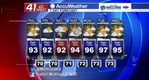
Showers and storms return tomorrow and last through weekend
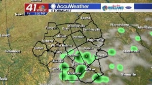
MACON, Georgia. (41NBC/WMGT) – Rain showers will be extremely isolated today, but better chances for showers and thunderstorms return tomorrow and into the weekend.
TODAY.
Most areas will stay dry again this afternoon as a slightly drier air mass is place for one final day. As we head into the afternoon, temperatures will be warming into the lower and middle 90’s under a partly sunny sky. Overnight tonight temperatures will cool off into the upper 60’s and lower 70’s under a partly sunny sky.
TOMORROW.
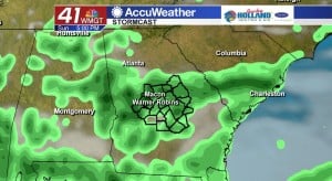
A coastal low pressure system is going to begin to work its way up the western peninsula of Florida tomorrow and that system will send a little bit more moisture our way tomorrow afternoon. Isolated showers are expected to form as we head into the afternoon hours. Temperatures will be in the low 90’s under a mix of sun and clouds.
WEEKEND AND BEYOND.
At times it will be a wet weekend across Middle Georgia, but that does not mean it will be a washout. Saturday and Sunday afternoons will see scattered showers and thunderstorms form during the afternoon like any typical summer afternoon. These storms will be hit or miss. No severe weather is expected this weekend. After the weekend we will dry out as we head into next week. Temperatures will be back on the rise as well as high temperatures are forecast to reach the upper 90’s early next week.
 Follow Meteorologist Dalton Mullinax on Facebook (Dalton Mullinax 41NBC) and Twitter (@MullinaxWX) for weather updates throughout the day. You can also watch his forecasts Monday through Friday on 41NBC News at Daybreak (5-7 a.m.) and 41Today (11 a.m.).

Leave a Reply