Scattered to numerous storms return by the afternoon
MACON, Georgia (41NBC/WMGT) – If you’re looking for consistency, you’ll find it in the short term forecast. Scattered to numerous showers and thunderstorms will persist again this afternoon 


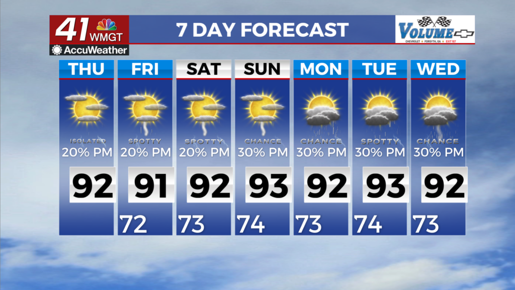
in association with a dying midlevel low as it gradually lifts northeastward and is absorbed into a trough to the north. Fortunately, convection has a bit more forward movement today as compared to yesterday, helping to limit the residency of heavy rainfall over any one spot. Still, given the soupy environment, any training cells could produce locally heavy rainfall and an isolated instance of flash flooding. Convective coverage will then dissipate after sunset with the loss of daytime heating. Consistency is key heading into today as we transition into a period of sustained southwesterly flow aloft around the western side of a building Bermuda High. A good smattering of scattered showers and thunderstorms can again be expected with daytime heating Thursday afternoon.


Highs may notch upward slightly, on Friday, although still fairly tame for early August, ranging from the upper 80s to lower 90s for most. The models are in good agreement with the long term weather pattern, which is characterized by a more prominent Bermuda High over the extended period. The coverage area will remain along the edge of this high pressure supporting a general southerly flow and the continuation of elevated moisture levels. This setup will reinforce the summertime pattern with weak flow aloft and a stricter daytime distribution of isolated to scattered pulse-type thunderstorms as we approach the weekend. Precipitation chances will remain in the 30 to 60 percent range over the area through the beginning portion of next week. Some of the storms may become strong with gusty winds and localized flash flooding concerns. This pattern will support a general downward trend in cloud cover and an upward trend in temperatures, rising slightly into the upper 80s to low 90s by the weekend.