


Scattered showers expected this afternoon and evening
MACON, Georgia. (41NBC/WMGT) – A weak backdoor cold front moving in from the northeast will trigger scattered showers this afternoon.
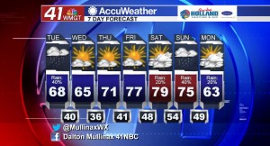
TODAY.
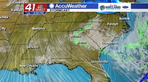
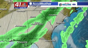
Yesterday evening’s cold front brought a few strong and severe storms to Middle Georgia, but that is all past us and today we are looking ahead to scattered showers this afternoon. The average high temperature for this time of year is 72°, but under a partly to mostly cloudy sky temperatures will struggle to make it out of the 60’s this afternoon. Showers will diminish in coverage as we head into the evening hours, but a few lingering light and isolated showers cannot be ruled out before midnight. After that we will see a clearing sky and temperatures falling into the upper 30’s and lower 40’s.
TOMORROW.
Sunshine makes a return tomorrow afternoon as we will be dealing with another cooler than normal day across the Peach State. Temperatures will be even cooler tomorrow afternoon as daytime high temperatures will top out in the lower and middle 60’s. Overnight tomorrow night temperatures will fall quickly into the middle 30’s after sunset due to a mostly clear sky.
EXTENDED FORECAST.
We stay dry through the rest of the work week, but a few showers try to return to our area on Saturday afternoon. On Saturday we will see temperatures climbing back into the upper 70’s and lower 80’s under a partly cloudy sky. Rain chances at the moment are running at just about 20%. Our wettest day of the next seven days will be on Sunday. A cold front is going to move through our area and bringing with it the chance for widespread rain and a few thunderstorms.
 Follow Meteorologist Dalton Mullinax on Facebook (Dalton Mullinax 41NBC) and Twitter (@MullinaxWX) for weather updates throughout the day. You can also watch his forecasts Monday through Friday on 41NBC News at Daybreak (5-7 a.m.) and 41Today (11 a.m.).

Leave a Reply