

Record high temperatures possible this week
MACON, Georgia. (41NBC/WMGT) – After a gorgeous weekend in Middle Georgia, we are going to take the great weather with us into the work week!
TODAY.
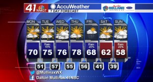
We saw a lot of sunshine across the state this past weekend, and while we will see some clouds across Middle Georgia this afternoon, I still expect to see a mix of sun and clouds that will lead to temperatures in the upper 60’s and low 70’s across the area. The average high temperature at the Middle Georgia Regional Airport for this time of year is 60° and we will be well above that not only today but for the rest of the week as well. Warmer air advecting into Middle Georgia will make overnight low temperatures much warmer as well. Temperatures tonight will hover in the low 50’s under a partly cloudy sky.
TOMORROW.
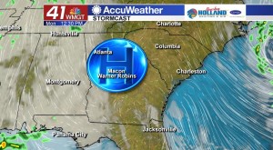
Very weak disturbances will move through our area over the next several days, but rain chances are extremely suppressed. While I do have a 10% chance of rain in my forecast for tomorrow, that is for an extremely light and isolated shower that can form in Middle Georgia. Atmospheric conditions are not conducive to shower development much at all this week. The warming trend continues tomorrow as afternoon high temperatures make it into the middle 70’s while overnight low temperatures only cool into the upper 50’s.
REST OF WEEK.
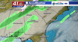
The rest of the week we will be dealing with well above average temperatures as well as mostly dry conditions. A weak cold front is expected to move through Middle Georgia on Friday, but once again rain chances at the moment are only running at about 20%.
 Meteorologist Dalton Mullinax on Facebook (Dalton Mullinax 41NBC) and Twitter (@MullinaxWX) for weather updates throughout the day. You can also watch his forecasts Monday through Friday on 41NBC News at Daybreak (5-7 a.m.) and 41Today (11 a.m.).


Leave a Reply