


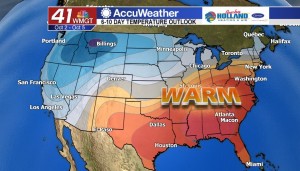
More record heat on the way today
MACON, Georgia. (41NBC/WMGT) – For three consecutive days this we have broken a record high temperature, and that trend is going to continue this afternoon as well.
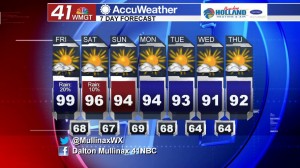
TODAY.

A weak frontal boundary draped across Middle Georgia will act as a forcing mechanism for a few showers this afternoon. I am still expecting very isolated coverage of these showers much like yesterday. What will not be isolated is the HOT temperatures. The average high temperature of 83° for this time of year is going to be an afterthought as we head into the afternoon hours. I expect temperatures to reach the middle to upper 90’s across the area. Where rain falls early in the afternoon it will keep temperatures down slightly. Tonight, temperatures will cool off into the middle and upper 90’s with just a little bit of cloud cover expected.
WEEKEND.

We stay hot and dry through the weekend for the most part. An extremely isolated shower cannot be ruled out tomorrow, but I’m keeping those rain chances at less than 10% for all of Middle Georgia. Record high temperatures will be in jeopardy of being broken this weekend as well.
Saturday Record: 96° (1986)
Sunday Record: 95° (1941)
NEXT WEEK.
We will continue with the warm and dry weather to start the week, but by next weekend a pattern change will be on the way. Temperatures closer to fall-like weather will be returning next weekend!
 Follow Meteorologist Dalton Mullinax on Facebook (Dalton Mullinax 41NBC) and Twitter (@MullinaxWX) for weather updates throughout the day. You can also watch his forecasts Monday through Friday on 41NBC News at Daybreak (5-7 a.m.) and 41Today (11 a.m.).

Leave a Reply